
Lyari River facts for kids
The Lyari River (which is called لیاری ندی in Urdu) is a small river in the big city of Karachi, Pakistan. It flows through the city from the northeast towards the center. Finally, it empties into the Arabian Sea near the Monora channel.
Contents
What is the Lyari River?
The Lyari River is one of the two main rivers in Karachi. The other important river is called the Malir River. The Lyari River is about 50 kilometres (which is about 30 miles) long. It is not a river that flows all year round. Instead, it is a seasonal river. This means it carries water mainly after heavy rains in its catchment area.
Where Does the Lyari River Flow?
The Lyari River starts in the hills to the northeast of Karachi. It then makes its way through the busy city. As it travels, it collects rainwater from a large area around it. This area is known as its catchment area. Think of a catchment area like a giant funnel that gathers all the rain and directs it into the river.
Why is the Lyari River Important to Karachi?
Even though it's a small and seasonal river, the Lyari River is very important for Karachi. It helps to drain away rainwater from the city, especially during the monsoon season. Without it, parts of Karachi could face more flooding. Over the years, many people have lived near the river, and it has played a role in the city's history and development.
What is a Seasonal River?
A seasonal river is different from a river that flows all the time. Rivers like the Lyari only carry water during certain times of the year. This usually happens after heavy rainfall or when snow melts. During dry seasons, the riverbed might become completely dry or only have small puddles of water. This is a common feature of rivers in areas with distinct wet and dry seasons.
The Lyari Expressway
Because the Lyari River flows through a very populated city, an important road was built along its banks. This road is called the Lyari Expressway. It is a major highway that helps people travel quickly across Karachi. The expressway was built to ease traffic and make commuting easier for thousands of people every day. It shows how the river's path has been used to help the city grow and develop.
Images for kids
-
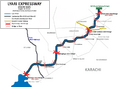
Lyari Expressway - Route Map

