Médéa Province facts for kids
Quick facts for kids
Médéa Province
ولاية المدية
|
|
|---|---|

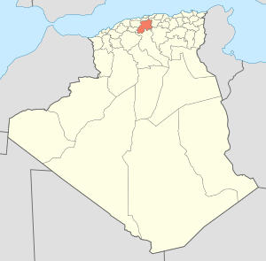
Map of Algeria highlighting Médéa
|
|
| Country | |
| Capital | Médéa |
| Area | |
| • Total | 8,866 km2 (3,423 sq mi) |
| Population | |
| • Total | 830,943 |
| • Density | 93.722/km2 (242.740/sq mi) |
| Time zone | UTC+01 (CET) |
| Area Code | +213 (0) 25 |
| ISO 3166 code | DZ-26 |
| Districts | 19 |
| Municipalities | 64 |
Médéa is a province in the country of Algeria. A province is like a large region or state. The main city and capital of this province is also called Médéa.
Contents
About Médéa Province
Médéa Province is located in the northern part of Algeria. It covers an area of about 8,866 square kilometers. That's roughly the size of a small country! As of 2008, more than 830,000 people lived there.
The province is known for its beautiful landscapes. It has mountains, plains, and forests. The climate can vary, with cooler temperatures in the higher areas.
How Médéa Province is Organized
Médéa Province is divided into smaller parts to help manage it. These parts are called districts and communes.
Districts of Médéa
The province has 19 main areas known as districts. Each district includes several smaller towns or villages.
- Aïn Boucif
- Aziz
- Béni Slimane
- Berrouaghia
- Chahbounia
- Chellalat El Adhaoura
- El Azizia
- El Omaria
- Guelb El Kébir
- Ksar El Boukhari
- Médéa
- Ouamri
- Ouled Antar
- Ouzera
- Seghouane
- Si Mahdjoub
- Sidi Naâmane
- Souaghi
- Tablat
Communes or Municipalities
Within these 19 districts, there are 64 smaller areas called communes or municipalities. These are like local towns or groups of villages. They help with local services and daily life for the people living there.
See also
 In Spanish: Provincia de Médéa para niños
 | Sharif Bey |
 | Hale Woodruff |
 | Richmond Barthé |
 | Purvis Young |

