Madison (town), Wisconsin facts for kids
Quick facts for kids
Town of Madison, Wisconsin
|
|
|---|---|

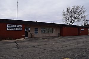
Town of Madison Municipal Building
|
|

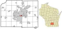
Location in Dane County and the state of Wisconsin.
|
|
| Country | |
| State | |
| County | Dane |
| Area | |
| • Total | 1.5 sq mi (4 km2) |
| • Land | 1.48 sq mi (3.8 km2) |
| • Water | 0.01 sq mi (0.03 km2) |
| Elevation | 846 ft (258 m) |
| Population
(2020)
|
|
| • Total | 6,236 |
| • Density | 4,324.1/sq mi (1,669.5/km2) |
| Time zone | UTC-6 (Central (CST)) |
| • Summer (DST) | UTC-5 (CDT) |
| Area code(s) | 608 |
| FIPS code | 55-48025 |
| GNIS feature ID | 1583626 |
The Town of Madison was a special type of local government area in Dane County, Wisconsin, United States. Unlike a city or village, a "town" in Wisconsin is a basic local government unit that covers areas outside of cities and villages.
This town stopped existing on October 31, 2022. Its last recorded population was 6,236 people in 2020. Most of the town's land was located along the Madison Beltline Highway. This area included several neighborhoods between the south side of the city of Madison and the north side of the city of Fitchburg.
The Town of Madison also had some smaller parts on the north side of Madison, near Maple Bluff. A few small areas were also on the west side of Madison, close to Whitney Way. Important places like the Dane County Expo Center and Alliant Energy Center were part of the Town of Madison.
Even though it was an "unincorporated community" (meaning it wasn't a city or village), the Town of Madison offered many services. These services are usually only found in cities or villages. They included trash and recycling, police, fire, and emergency medical help. The town also provided water and sewer services, and it had three public parks for its residents.
Contents
History of the Town of Madison
The original Town of Madison was quite large, covering about 36 square miles (93 km²). It was officially created on February 2, 1846.
In 1856, the Wisconsin Legislature (the state's law-making body) created the city of Madison. This meant that the remaining land became what was left of the Town of Madison. Over many years, most of this land was slowly added to other cities and villages. The City of Madison took over a lot of it.
This process of adding land to cities is called annexation. Because of annexation, the Town of Madison became a collection of separate areas. These areas were not connected to each other. For example, the Burr Oaks neighborhood had parts in both the Town of Madison and the City of Madison. These parts were connected by Cypress Way. The same was true for parts of the Capitol View Heights neighborhood, connected by Sundstrom and Nygard Streets.
Why the Town of Madison Dissolved
Over time, there were many discussions and even efforts by the state government to simply get rid of the town. Finally, in 2003, an agreement was reached. This agreement planned for the remaining parts of the town to be absorbed by the city of Madison and the city of Fitchburg.
By this time, the town was much smaller, less than 3.9 square miles (10 km²), including water areas. The agreement set a date for the dissolution: October 31, 2022. The town officially ceased to exist on that date, as planned.
Geography and Population Facts
The Town of Madison was quite small by the time it dissolved. It had a total area of about 1.5 square miles (3.9 km²). Most of this was land (1.4 square miles or 3.6 km²), with a very small amount of water.
The population of the Town of Madison changed over many years:
| Historical population | |||
|---|---|---|---|
| Census | Pop. | %± | |
| 1870 | 857 | — | |
| 1880 | 735 | −14.2% | |
| 1890 | 919 | 25.0% | |
| 1900 | 1,567 | 70.5% | |
| 1910 | 1,705 | 8.8% | |
| 1920 | 2,327 | 36.5% | |
| 1930 | 3,355 | 44.2% | |
| 1940 | 4,638 | 38.2% | |
| 1950 | 4,195 | −9.6% | |
| 1960 | 4,925 | 17.4% | |
| 1970 | 4,568 | −7.2% | |
| 1980 | 6,162 | 34.9% | |
| 1990 | 6,442 | 4.5% | |
| 2000 | 7,005 | 8.7% | |
| 2010 | 6,279 | −10.4% | |
| 2020 | 6,277 | 0.0% | |
| U.S. Decennial Census | |||
In 2010, there were 6,279 people living in the town. The population density was about 4,234 people per square mile (1,669.5/km²). This means a lot of people lived in a small area.
The people living in the town came from many different backgrounds. About 54.6% were White, 20.1% were Black or African American, and 5.9% were Asian. About 28.0% of the population identified as Hispanic or Latino.
The average age of people in the town was about 28.6 years. Many young people lived there, with 23.2% under 18 years old and 16.8% between 18 and 25.
See also
 In Spanish: Madison (condado de Dane, Wisconsin) para niños


