Malva, Spain facts for kids
Quick facts for kids
Malva
|
|||
|---|---|---|---|

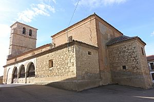
Church of San Miguel
|
|||
|
|||
| Country | |||
| Autonomous community | |||
| Province | |||
| Comarca | Alfoz de Toro | ||
| Judicial District | Zamora | ||
| Mancomunidad | Norte-Duero | ||
| Area | |||
| • Total | 27.33 km2 (10.55 sq mi) | ||
| Elevation | 713 m (2,339 ft) | ||
| Population
(2018)
|
|||
| • Total | 131 | ||
| • Density | 4.793/km2 (12.41/sq mi) | ||
| Demonym(s) | Malvarisco / Malvarisca | ||
| Time zone | UTC+1 (CET) | ||
| • Summer (DST) | UTC+2 (CEST) | ||
| Postal code |
49832
|
||
| Area code | (+34) 980 | ||
Malva is a small town, also known as a municipality. It is found in the province of Zamora. This area is part of Castile and León, a larger region in Spain. In 2018, about 131 people lived in Malva.
Exploring Malva's Location
Malva is located in a special part of Spain. It sits south of a protected area. This area is called the Lagunas de Villafáfila natural reserve. A natural reserve is a place where nature is kept safe.
How Far is Malva from Other Cities?
Malva is not far from some bigger cities. It is about 17 kilometers from Toro. The city of Zamora is 33 kilometers away. Valladolid is a bit further, at 83 kilometers. These distances help you understand where Malva is on the map.
See also
 In Spanish: Malva (Zamora) para niños

All content from Kiddle encyclopedia articles (including the article images and facts) can be freely used under Attribution-ShareAlike license, unless stated otherwise. Cite this article:
Malva, Spain Facts for Kids. Kiddle Encyclopedia.


