Mangatāwhiri River facts for kids
Quick facts for kids Mangatāwhiri River |
|
|---|---|

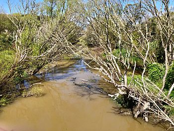
Mangatāwhiri River between the old and new Great South Rd bridges
|
|
| Country | New Zealand |
| Physical characteristics | |
| River mouth | Waikato River |
| Length | 20 km (12 mi) |
| Basin features | |
| Basin size | 104 km2 (40 sq mi) |
The Mangatāwhiri River is a river located in the North Island of New Zealand. It flows through parts of the Auckland and Waikato areas. This river is about 20 kilometers (12 miles) long.
It starts in the Hunua Ranges, which are hills southeast of a town called Clevedon. The river then flows southwest. Near the town of Pokeno, it goes through a network of canals that help with irrigation. Finally, the Mangatāwhiri River joins the larger Waikato River near the town of Mercer.
What's in a Name?
The name Mangatāwhiri has a special meaning. The New Zealand Ministry for Culture and Heritage explains that it means "Tāwhiri tree stream." A Tāwhiri is a type of native New Zealand tree.
Water for Auckland
The upper parts of the Mangatāwhiri River are very important for Auckland City. Here, dams have been built to create large reservoirs. These reservoirs store water that is used by the people living in Auckland.
A Look at History
The Mangatāwhiri River holds a significant place in New Zealand's history. On July 12, 1863, British troops crossed this river. This action, ordered by Governor George Grey, marked the beginning of the Waikato Land Wars. These wars were a major conflict between the British forces and the Māori in the Waikato region.
 | William Lucy |
 | Charles Hayes |
 | Cleveland Robinson |

