
Manica Province facts for kids
Quick facts for kids
Manica
|
|
|---|---|

Looking down from Mount Zembe
|
|

Manica, Province of Mozambique
|
|
| Country | Mozambique |
| Capital | Chimoio |
| Area | |
| • Total | 62,272 km2 (24,043 sq mi) |
| Highest elevation | 2,436 m (7,992 ft) |
| Population
(2017 census)
|
|
| • Total | 1,945,994 |
| • Density | 31.24990/km2 (80.9369/sq mi) |
| Postal code |
22xx
|
| Area code(s) | (+258) 251 |
Manica is a special area in Mozambique, a country in southern Africa. It's like a big region or state, and its main city, or capital, is Chimoio.
This province has some cool natural features! The Save River forms its southern edge. You can also find part of the famous Zambezi River in the northeast. Manica is home to Mount Binga, which is the highest mountain in all of Mozambique. It stands tall at 2,436 meters (about 7,992 feet) and is located close to the border with Zimbabwe.
Manica's Local Areas: Districts
Manica Province is divided into 12 smaller areas called districts. Each district has its own local government and helps manage the province. These districts are:
- Báruè District
- Chimoio District
- Gondola District
- Guro District
- Macate District
- Machaze District
- Macossa District
- Manica District
- Mossurize District
- Sussundenga District
- Tambara District
- Vanduzi District
Images for kids
-
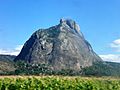
Mount Vanduzi
-
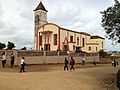
Gondola church, Manica Province

.jpg)
See also
 In Spanish: Provincia de Manica para niños

All content from Kiddle encyclopedia articles (including the article images and facts) can be freely used under Attribution-ShareAlike license, unless stated otherwise. Cite this article:
Manica Province Facts for Kids. Kiddle Encyclopedia.