Marijampolė County facts for kids
Quick facts for kids
Marijampolė County
Marijampolės apskritis
|
|||
|---|---|---|---|
|
County
|
|||

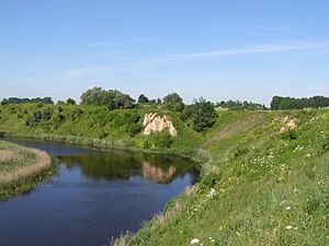
Marijampolė (Meškučiai) second hillfort
|
|||
|
|||

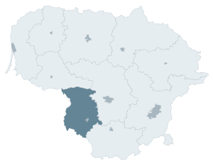
Location of Marijampolė County
|
|||
| Country | |||
| Administrative centre | Marijampolė | ||
| Area | |||
| • Total | 4,463 km2 (1,723 sq mi) | ||
| Population
(2016-01-20)
|
|||
| • Total | 149,125 | ||
| • Density | 33.414/km2 (86.541/sq mi) | ||
| Time zone | UTC+2 (EET) | ||
| • Summer (DST) | UTC+3 (EEST) | ||
| ISO 3166 code | LT-MR | ||
Marijampolė County is one of the ten main regions, or counties, in the country of Lithuania. It's like a large administrative area. The biggest and most important city in this county is Marijampolė, which is also its capital.
On July 1, 2010, the way counties were managed in Lithuania changed. The county administration, which used to handle many local tasks, was officially ended. Now, the different parts of the county work more closely with the central government.
Parts of Marijampolė County
Marijampolė County is made up of several smaller areas called municipalities. Each municipality has its own local government that helps run things for the people living there. Think of them as smaller districts within the larger county.
Here are the municipalities that make up Marijampolė County:
| Kalvarija Municipality | |
| Kazlų Rūda Municipality | |
| Marijampolė Municipality | |
| Šakiai District Municipality | |
| Vilkaviškis District Municipality |
See also
 In Spanish: Provincia de Marijampolė para niños
 | Selma Burke |
 | Pauline Powell Burns |
 | Frederick J. Brown |
 | Robert Blackburn |


