Marine conservation zones in Yorkshire facts for kids
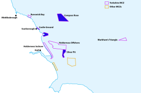
The marine conservation zones in Yorkshire are special areas in the sea around Yorkshire that are protected. These zones were created in 2016 and 2019. They help to look after important marine wildlife and habitats.
Before these zones were set up, there was a big study that suggested 127 areas across the UK should be protected. Eight of these were near the Yorkshire coast. However, the government initially decided to protect fewer areas, which caused some discussion.
In 2020, a review suggested that nearly 50 more areas around the UK, including three off the Yorkshire coast, should become "Highly Protected Marine Areas" (HPMAs). In these very strict zones, activities like dredging (scooping up the seabed), dumping sewage, drilling for oil, building offshore wind turbines, and even catch-and-release sea fishing would be banned. This is to give marine life the best chance to thrive.
Contents
Protecting Our Oceans: A History
Protecting the ocean has been a global effort for many years. In 1999, a special group was set up in the UK to find better ways to protect our seas. This was part of a bigger worldwide movement to look after nature.
In 2008, a project called the Marine Conservation Zone Project began. Its goal was to figure out which areas around England, Wales, and Northern Ireland should become Marine Conservation Zones (MCZs). This project led to a new law in 2009 called the Marine and Coastal Access Act 2009.
The UK was divided into four areas for this project. Each area suggested places to become MCZs. The first group of MCZs was created in 2013, but none of them were in Yorkshire. The Yorkshire MCZs were chosen later, in 2016 and 2019.
Yorkshire's Marine Conservation Zones
Here are the four Marine Conservation Zones in Yorkshire:
| Name | Year Designated | Area (km²) | Depth Range | Main Features |
|---|---|---|---|---|
| Holderness Inshore | 2016 | 191.92 miles (308.87 km) | Sea level to 49 feet (15 m) | Cobble, sand, chalk, peat, clay, various marine animals and plants. |
| Holderness Offshore | 2019 | 454 square miles (1,176 km2) | 33 feet (10 m) – 160 feet (50 m) | Ross worms, crabs, lobsters, ocean quahogs, harbour porpoises. |
| Markham's Triangle | 2019 | 77 square miles (200 km2) | 98 feet (30 m) – 160 feet (50 m) | Sand eels, grey seals, harbour porpoises. |
| Runswick Bay | 2016 | 26.13 square miles (67.67 km2) | 33 feet (10 m) – 98 feet (30 m) | Rocky areas, kelp, red seaweed, mussels, limpets, barnacles, sponges, sea squirts, sea urchins, herring, cod, plaice, ocean quahog. |
Holderness Inshore
The Holderness Inshore MCZ is a large area, stretching over 191 miles (308 km) along the coast. It goes from the tip of Spurn Point in the south up to the village of Skipsea in the north. This zone reaches about 3 nautical miles (5.6 km; 3.5 mi) out into the sea from the shore.
The seabed here is like a beautiful patchwork of different materials, including cobble, sand, chalk, and even patches of peat and clay. This varied environment is home to many different sea creatures and plants, such as wrasse, European eels, dab, and important shellfish like crabs and lobsters.
Holderness Offshore
The Holderness Offshore MCZ is located about 6 nautical miles (11 km; 6.9 mi) away from the coast of the East Riding of Yorkshire. It's a deep area, reaching 160 feet (50 m) down, and covers a huge space of 454 square miles (1,176 km2).
This zone is especially known for its interesting marine life, including ross worms, crabs, lobsters, and a type of very long-lived clam called ocean quahogs. This area also overlaps with another protected zone that helps to protect harbour porpoises.
Markham's Triangle
Markham's Triangle is quite far out at sea, over 84 miles (135 km) from the Holderness coast. This area is important because it supports lots of sand eels. Sand eels are a key food source for many seabirds.
Surveys have also shown that grey seals and harbour porpoises swim through this area. Sadly, Markham's Triangle has seen a lot of trawl fishing in recent years, which has left marks on the seabed. Protecting this area helps the marine life recover.
Runswick Bay
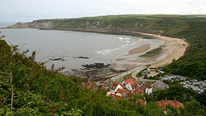
Runswick Bay became a protected MCZ in January 2016. It stretches about 3 nautical miles (5.6 km; 3.5 mi) out to sea and covers an area of 26.13 square miles (67.67 km2). It's recognized as a protected area on a worldwide database.
This MCZ has shallow rocky areas that provide safe homes for crabs, anemones, and starfish. The seabed is also a great place for kelp and red seaweed to grow. Closer to the shore, you can find mussels, limpets, and barnacles. Deeper down, there are sponges, sea squirts, and sea urchins. Important visitors like harbour porpoises and kittiwakes also come to this area.
The deeper parts of Runswick Bay are important places for fish like herring, sprat, cod, and plaice to lay their eggs. The protection plan for this zone specifically mentions the ocean quahog (a type of clam) and ten different types of rock and seabed that need to be managed and protected.
Even though there isn't a single big plan for all MCZs, Runswick Bay has been a no-trawling zone for many years. Dredging is also banned, and netting is carefully controlled to protect the marine environment.
Proposed Marine Conservation Zones
Besides the four protected zones, there are other areas that have been suggested to become MCZs. These areas also have special features that make them important for marine life.
| Name | Year Proposed | Area (km²) | Depth Range | Main Features |
|---|---|---|---|---|
| Castle Ground | 2019 | 1.4 square miles (3.7 km2) | Sea level | Shoreline habitats, seaweeds, sea hares, crabs, molluscs, anemones, sponges, starfish, brittlestars, important for foraging seabirds. |
| Compass Rose | 2016 | 213 square miles (552 km2) | 160 feet (50 m) | Cup corals, anemones, sponges, mussels, worms, starfish, brittle stars, important spawning and nursery grounds for fish. |
| Flamborough Head | N/A | 0.36 square miles (0.94 km2) | Sea level | Chalk cliffs and rocky outcrops, already a "no-take zone" for fishing. |
| Silver Pit | 2019 | 65 square miles (168 km2) | 98 feet (30 m) – 230 feet (70 m) | Mussels, brittle stars, sea squirts, queen scallops, squat lobsters, pink shrimp, spawning ground for many fish, food for seabirds, minke whales, dolphins, porpoises. |
Castle Ground
Castle Ground is located off the coast near Scarborough. This area was suggested for protection because of its important shoreline habitats and the many bird species that use it. It's named after Scarborough Castle.
This area is home to seaweeds, sea hares, crabs, and various molluscs like blue-rayed limpets. You can also find anemones, sponges, starfish, and brittlestars here. In winter, a nearby area called Filey Brigg supports a large number of purple sandpipers and is important for seabirds like kittiwakes looking for food.
Compass Rose
Compass Rose is about 19 miles (30 km) off the coast of Yorkshire, between Whitby and Scarborough. This large area, covering over 210 square miles (550 km2), is known for something called the Flamborough Front. This is where warmer waters from the southern North Sea mix with cooler waters from the northern North Sea, creating a special environment.
The water in this proposed zone can be up to 160 feet (50 m) deep. It supports cup corals, anemones, sponges, mussels, worms, starfish, and brittle stars. It's also a very important place for fish like plaice, herring, lemon sole, and sandeels to lay their eggs. Plus, it's a key nursery area where young cod, whiting, and sprat grow up.
Flamborough Head
Flamborough Head is already a special protected area. It's famous for being the most northerly place in the United Kingdom where chalk cliffs stick out into the sea. The chalk here erodes (wears away) slower on the north side than on the south, forming rocky outcrops, headlands, and cliffs. This site was officially protected on April 1, 2005.
For a long time, this area has been a "no-take zone" for fishing, meaning fishing is not allowed. The proposed zone would have extended this protected area about 2,300 feet (700 m) out to sea.
Silver Pit
Silver Pit was suggested for protection in 2019 but did not become an MCZ. It's a deep, trench-like valley on the floor of the North Sea. Fishermen in the 1800s knew it as a good spot to catch flatfish like sole and plaice. Scientists believe this deep trench was carved out by melting glaciers long ago.
The depth of Silver Pit ranges between 98 feet (30 m) and 230 feet (70 m). It's home to a variety of wildlife, including mussels, brittle stars, sea squirts, queen scallops, squat lobsters, and pink shrimp. It's also a spawning ground for many fish, such as lemon sole, sprat, whiting, cod, Dover sole, plaice, and herring. Seabirds like puffins, common guillemots, kittiwakes, fulmars, and northern gannets come here to find food. Even minke whales, white-beaked dolphins, and porpoises have been seen in this area.
The Future of Marine Protection
In June 2020, a review suggested that three areas along the Yorkshire coastline should become even stricter protection zones, known as Highly Protected Marine Areas (HPMAs). This would mean a complete ban on activities like dredging, sewage dumping, drilling, building offshore wind turbines, and even catch-and-release sea fishing.
These three areas in Yorkshire would join over 40 others across the UK to become HPMAs. The specific areas noted for this highest level of protection were Markham's Triangle, Dogger Bank, and Bempton Cliffs/Flamborough Head. This shows a growing effort to give our marine environments the best possible chance to recover and thrive.
 | William Lucy |
 | Charles Hayes |
 | Cleveland Robinson |


