Marowin Brook (New South Wales) facts for kids
Quick facts for kids Marowin BrookNew South Wales |
|
|---|---|

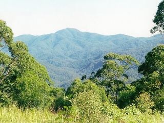
Country round Marowin Brook
|
|
| • Density | 17/km2 (44/sq mi) |
| Elevation | 110 m (361 ft) |
| LGA(s) | Port Macquarie-Hastings Council |
| Region | mid north coast of New South Wales |
| State electorate(s) | New South Wales |
| Managing authorities | NSW National Parks and Wildlife Service |
Marowin Brook is a lovely creek located in Upper Rollins Plains, New South Wales, Australia. It's a special place because it flows entirely within the beautiful Kumbatine National Park. This means the creek and its surroundings are kept wild and natural. The brook is about 110 metres above sea level.
About Marowin Brook
Marowin Brook is a creek found in the Upper Rollins Plains area of New South Wales. It's quite unique because its entire path is inside the protected Kumbatine National Park. This helps keep the brook and its environment untouched. The creek sits about 110 metres above sea level. It eventually flows into the Wilson River.
Climate and Environment
The area around Marowin Brook has a subtropical climate. This means it's generally warm all year round. The average temperature is about 17 degrees C. January is usually the hottest month, with temperatures averaging 22 degrees C. July is the coolest month, with an average of 10 degrees C.
The region receives a lot of rain, about 1,846 millimeters each year. February is the wettest month, getting around 373 millimeters of rain. September is the driest, with only about 34 millimeters.
Trees and Plants
The land around Marowin Brook is covered with tall trees. You can find many Blackbutt and Tallowwood trees here. Some of these trees can grow incredibly tall, reaching heights of up to 80 metres. These large trees are an important part of the local ecosystem.
 | Toni Morrison |
 | Barack Obama |
 | Martin Luther King Jr. |
 | Ralph Bunche |


