
Cottrellville Township, Michigan facts for kids
Quick facts for kids
Cottrellville Township, Michigan
|
|
|---|---|

Cottrellville Township Hall
|
|

Location within St. Clair County
|
|

Cottrellville Township, Michigan
Location in Michigan
|
|
| Country | United States |
| State | Michigan |
| County | St. Clair |
| Formed | 1822 |
| Area | |
| • Total | 22.4 sq mi (58.0 km2) |
| • Land | 21.2 sq mi (54.9 km2) |
| • Water | 1.2 sq mi (3.1 km2) |
| Elevation | 597 ft (182 m) |
| Population
(2020)
|
|
| • Total | 3,406 |
| • Density | 152.1/sq mi (58.72/km2) |
| Time zone | UTC-5 (Eastern (EST)) |
| • Summer (DST) | UTC-4 (EDT) |
| ZIP code(s) |
48039
|
| Area code(s) | 810 |
| FIPS code | 26-18400 |
| GNIS feature ID | 1626136 |
Cottrellville Township is a civil township located in St. Clair County, Michigan, in the United States. It's like a local government area that manages services for its residents. According to the 2020 Census, 3,406 people call Cottrellville Township home.
Contents
Neighborhoods in Cottrellville
Cottrellville Township has several small neighborhoods or areas. These are called unincorporated communities. They are not separate cities, but part of the township. Here are some of them:
- Avalon Beach is found along River Road/M-29 (42°41′20″N 82°30′30″W / 42.68889°N 82.50833°W).
- Broadbridge Station is located where River Road/M-29 meets Broadbridge Road (42°40′43″N 82°30′43″W / 42.67861°N 82.51194°W).
- Cherry Beach is at River Road/M-29 and Little Avenue (42°41′05″N 82°30′35″W / 42.68472°N 82.50972°W).
- Martindale Beach is on River Road/M-29 and Paradise Road. It is just south of Marine City (42°41′29″N 82°30′27″W / 42.69139°N 82.50750°W).
- Roberts Landing is at River Road/M-29 and Roberts Road (42°39′35″N 82°30′57″W / 42.65972°N 82.51583°W).
- Starville is along Starville Road, between Broadbridge Road and Shea Road (42°40′52″N 82°35′16″W / 42.68111°N 82.58778°W).
A Look at Cottrellville's Past
Cottrellville Township was officially started in 1822. This means it has a long history! One of the first people to be in charge was A. Hemminger, who was the Supervisor. Some of the very first families to settle here were the Cotterals (who the township is named after), the Wards, and the Browns.
The land in Cottrellville is very good for farming. It rises gently from the river, and the soil is rich. There used to be some marshy areas near the river, but even those could be farmed. In the past, the main places where people lived were Marine City or Roberts' Landing.
The number of people living in Cottrellville Township has changed over time:
- In 1845, there were 727 people.
- By 1854, the population grew to 1,442.
- In 1864, it reached 1,930.
- By 1870, there were 2,371 residents.
- In 1880, the population was 2,904.
Where is Cottrellville Located?
Cottrellville Township covers a total area of about 22.4 square miles (58.0 square kilometers). Most of this area, about 21.2 square miles (54.9 square kilometers), is land. The rest, about 1.2 square miles (3.1 square kilometers), is water. This means a small part of the township is made up of rivers or other water bodies.
Who Lives in Cottrellville?
In the year 2000, there were 3,814 people living in Cottrellville Township. These people lived in 1,384 homes, and 1,055 of those were families.
The population was made up of different age groups:
- About 27.5% of the people were under 18 years old.
- About 7.5% were between 18 and 24 years old.
- The largest group, 30.6%, was between 25 and 44 years old.
- About 23.9% were between 45 and 64 years old.
- And 10.5% were 65 years old or older.
The average age of someone living in the township was 37 years old. For every 100 females, there were about 101.8 males.
Most families in Cottrellville Township earned a good income. The average income for a family was about $53,750 per year. Only a small number of families, about 2.5%, lived below the poverty line. This means most people in Cottrellville Township were doing well financially.
Images for kids
-
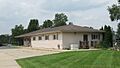
Cottrellville Township Hall
-
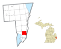
Location within St. Clair County
See also
 In Spanish: Municipio de Cottrellville para niños
