Maryneal, Texas facts for kids
Quick facts for kids
Maryneal
|
|
|---|---|
| Country | United States |
| State | Texas |
| County | Nolan |
| Elevation | 2,566 ft (782 m) |
| Time zone | UTC-6 (Central (CST)) |
| • Summer (DST) | UTC-5 (CDT) |
| ZIP codes |
79535
|
| GNIS feature ID | 1341044 |
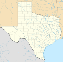
Maryneal is a small, unincorporated community located in the southern part of Nolan County, Texas, in the United States. An unincorporated community is a place that isn't officially governed by its own local city government. It's often a small settlement or village.
Maryneal is situated along a road called Farm to Market Road 608, which is south of the city of Sweetwater. Sweetwater is the main town, or county seat, of Nolan County. Maryneal sits at an elevation of about 2,566 feet (782 meters) above sea level. Even though it's not a big city, Maryneal has its own post office and a ZIP code of 79535. In the year 2000, the area covered by this ZIP code had a population of 181 people.
History of Maryneal
How Maryneal Began
Maryneal was founded in 1907. It grew up around the Kansas City, Mexico and Orient Railway, which was a railroad line. Today, this same route is used by the Texas and Oklahoma Railroad.
What's in a Name?
The exact origin of the name "Maryneal" is a bit of a mystery! It's believed to have been named after one or more people, but historians aren't completely sure who.
Maryneal's Early Importance
In its early days, Maryneal was actually more important than it is now. For example, when Nolan County was deciding where its main government center (the county seat) should be, Maryneal received a good number of votes, though Sweetwater ultimately won. Also, a post office was moved to Maryneal from another nearby community called Decker, showing its growing importance at the time.
 | Jessica Watkins |
 | Robert Henry Lawrence Jr. |
 | Mae Jemison |
 | Sian Proctor |
 | Guion Bluford |


