
Matakitaki River facts for kids
The Matakitaki River is a cool river in the north of New Zealand's South Island. It's like a smaller stream that flows into the bigger Buller River. The Matakitaki River is about 65 kilometres (40 miles) long. It starts near the Lewis Pass and joins the Buller River near a town called Murchison. It also has a main side river called the Glenroy River.
.jpg)
Contents
Fun on the Water: Whitewater Adventures
The Matakitaki River is a great place for exciting water sports like whitewater kayaking and rafting! It has two popular sections that people often paddle.
Middle Matakitaki
This part of the river is about 10 kilometres (6 miles) upstream from Murchison. It's known as a "Grade 2+" section. This means the rapids are fairly easy, but still fun, with some good spots to play in the water.
Lower Matakitaki
This section is closer to Murchison. It's a shorter, more challenging ride. At medium water levels, it's a "Grade 3+" river, meaning the rapids are more difficult and require good paddling skills. When the water is higher, it can become a "Grade 4," which is even more challenging and exciting!
Gold Mining History
The Matakitaki River and its smaller streams have been important for gold mining for a long time, both in the past and even today. The gold found here is known to be very pure and often comes in larger pieces. Many flat areas along the river are used for mining. There are even special dredging machines that dig for gold right in the riverbed in the "Lower" and "Middle" sections.
Fishing for Trout
This river is a very important place for fishing. Many people love to fish here, not just because they can catch a lot of fish, but also because it's known as a "trophy river." This means you can often catch really big, impressive fish here!
River Power: Hydroelectric Plans
Sometimes, rivers are used to create electricity. A company called Network Tasman once thought about building a 30-megawatt hydroelectric power station on the Matakitaki River. However, a group called Whitewater NZ was worried that this power station would affect the popular "Middle Matakitaki" section, which is loved by whitewater paddlers. For now, the plans to build a power station on the river are on hold because of economic reasons.
Images for kids
-
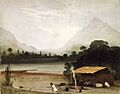
A painting by William Fox from 1847. It shows explorers Thomas Brunner and Charles Heaphy resting, while their Maori guide catches a weka bird.

