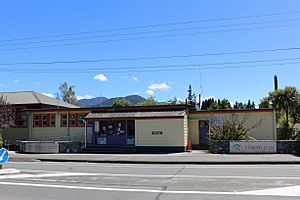
Murchison, New Zealand facts for kids
Quick facts for kids
Murchison
|
|
|---|---|
|
Rural settlement
|
|
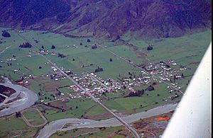
Aerial view of Murchison in 1978
|
|
| Country | New Zealand |
| Territorial authority | Tasman |
| Ward | Lakes-Murchison Ward |
| Electorates |
|
| Area | |
| • Total | 4.34 km2 (1.68 sq mi) |
| Population
(June 2023)
|
|
| • Total | 510 |
| • Density | 117.5/km2 (304/sq mi) |
| Postcode(s) |
7007
|
| Area code(s) | 03 |
Murchison is a small town located in the Tasman Region on the South Island of New Zealand. It sits in a special area called the "Four Rivers Plain." This is where the Buller River and the Mātakitaki River meet. The other two rivers in this area are the Mangles River and the Matiri River.
Murchison is a service town for the farms around it. It is about halfway between Westport and Nelson. The town was named after Roderick Murchison, a Scottish geologist. He helped start the Royal Geographical Society.
Contents
History of Murchison
The Murchison area has a rich history. It goes back to the time of gold miners and early settlers. A place called Lyell, which was once a big gold mining town, is nearby. It shows how quickly nature can reclaim old settlements.
Murchison was also the center of a very strong earthquake in 1929. This event is also known as the Buller earthquake.
People of Murchison
Murchison is a rural settlement. It covers about 4.34 square kilometers. In 2018, about 606 people lived there. This means there were about 140 people per square kilometer.
The population of Murchison has grown a lot. In 2006, there were 336 people. By 2018, it had increased to 606 people. This was a jump of over 80% in 12 years.
Most people in Murchison are of European background (96%). About 5% are Māori. Other groups include Pasifika and Asian people.
When asked about religion, most people (58.9%) said they had no religion. About 27.7% were Christian.
Things to Do in Murchison
Murchison is a great place for whitewater sports. Many rivers are close by, like the Gowan, Mangles, Matiri, Glenroy, Matakitaki, Maruia, and Buller rivers. These rivers offer different levels of whitewater fun. Some are easy (Class 2), and some are more challenging (Class 4).
Two National Parks are also nearby. These are Kahurangi and Nelson Lakes. You can also visit Lake Matiri and Mount Owen.
Important Buildings in Murchison
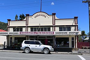
Hodgsons of Murchison
Hodgsons has been the local store in Murchison for over 100 years. It is a historic place recognized by Heritage New Zealand. The store was badly damaged during the 1929 Murchison earthquake.
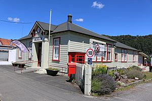
Murchison Museum
The Murchison Museum tells the story of the 1929 Murchison Earthquake. It shows how the earthquake affected the town. You can find the museum at 60 Fairfax Street.
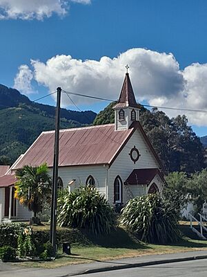
St Paul's Anglican Church
St Paul's Church was built in 1905. It has a gothic style. A Nelson architect named David Greg designed it. The church is also listed as a historic place.
Travel and Services
Murchison is on State Highway 6. This is a main road connecting Nelson and Marlborough with the West Coast. It is also one of the main ways to get from Nelson to Christchurch.
After the 2016 Kaikōura earthquake, traffic increased a lot. The earthquake closed other main roads. So, all traffic going north from Christchurch had to go through Murchison. This meant more cars and people in the town. Murchison has a petrol station and an electric car charging station.
The town also has important services. These include fresh water, stormwater, and wastewater systems. Electricity comes from a substation near the town.
Education in Murchison
Murchison Area School is a school for all students. It teaches students from Year 1 to Year 13. The school has about 299 students.
Famous People from Murchison
- Annette King – a politician and diplomat
- Muriel Bell – a nutritionist and medical researcher
Climate in Murchison
| Climate data for Murchison (1991–2020 normals, extremes 1969–1976, 1998–2013) | |||||||||||||
|---|---|---|---|---|---|---|---|---|---|---|---|---|---|
| Month | Jan | Feb | Mar | Apr | May | Jun | Jul | Aug | Sep | Oct | Nov | Dec | Year |
| Record high °C (°F) | 36.8 (98.2) |
36.8 (98.2) |
32.0 (89.6) |
27.8 (82.0) |
27.4 (81.3) |
19.3 (66.7) |
18.0 (64.4) |
21.7 (71.1) |
23.9 (75.0) |
27.4 (81.3) |
32.4 (90.3) |
33.5 (92.3) |
36.8 (98.2) |
| Mean daily maximum °C (°F) | 25.8 (78.4) |
25.8 (78.4) |
23.1 (73.6) |
18.8 (65.8) |
14.6 (58.3) |
10.3 (50.5) |
10.3 (50.5) |
13.6 (56.5) |
15.9 (60.6) |
18.3 (64.9) |
21.2 (70.2) |
23.5 (74.3) |
18.4 (65.2) |
| Daily mean °C (°F) | 18.2 (64.8) |
18.3 (64.9) |
16.0 (60.8) |
12.8 (55.0) |
9.7 (49.5) |
6.4 (43.5) |
5.7 (42.3) |
8.1 (46.6) |
9.9 (49.8) |
12.0 (53.6) |
14.3 (57.7) |
16.7 (62.1) |
12.3 (54.2) |
| Mean daily minimum °C (°F) | 10.7 (51.3) |
10.9 (51.6) |
9.0 (48.2) |
6.7 (44.1) |
4.9 (40.8) |
2.5 (36.5) |
1.1 (34.0) |
2.7 (36.9) |
4.0 (39.2) |
5.6 (42.1) |
7.4 (45.3) |
9.9 (49.8) |
6.3 (43.3) |
| Record low °C (°F) | 0.5 (32.9) |
0.5 (32.9) |
−2.2 (28.0) |
−3.1 (26.4) |
−4.6 (23.7) |
−8.8 (16.2) |
−7.4 (18.7) |
−6.3 (20.7) |
−4.2 (24.4) |
−3.5 (25.7) |
−0.8 (30.6) |
0.5 (32.9) |
−8.8 (16.2) |
| Average rainfall mm (inches) | 126.4 (4.98) |
75.4 (2.97) |
89.7 (3.53) |
137.9 (5.43) |
139.8 (5.50) |
144.7 (5.70) |
151.1 (5.95) |
134.3 (5.29) |
143.3 (5.64) |
167.2 (6.58) |
139.4 (5.49) |
132.1 (5.20) |
1,581.3 (62.26) |
| Source: NIWA (rain 1971–2000) | |||||||||||||
 | William M. Jackson |
 | Juan E. Gilbert |
 | Neil deGrasse Tyson |


