Maxcanú Municipality facts for kids
Quick facts for kids
Maxcanú
|
|
|---|---|

Region 1 Poniente #048
|
|
| Country | |
| State | |
| Government | |
| • Type | |
| Area | |
| • Total | 1,320.82 km2 (509.97 sq mi) |
| Population
(2005)
|
|
| • Total | 21,704 |
| Time zone | UTC-6 (Central Standard Time) |
| • Summer (DST) | UTC-5 (Central Daylight Time) |
| INEGI Code | 048 |
| Major Airport | Merida (Manuel Crescencio Rejón) International Airport |
| IATA Code | MID |
| ICAO Code | MMMD |
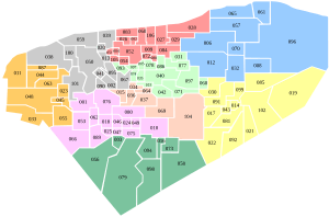
Maxcanú Municipality (pronounced Mahsh-kah-NOO) gets its name from the Yucatec Maya language. It means "his four monkeys." This area is a municipality, which is like a county, in the Mexican state of Yucatán. The main town in this area is also called Maxcanú. The municipality covers about 1,321 square kilometers. It is located about 52 kilometers southwest of the big city of Mérida.
Contents
Geography of Maxcanú
Maxcanú Municipality shares its borders with several other areas. To the north, it borders Celestún, Samahíl, and Kinchil. To the east, it borders Chocholá, Kopomá, and Opichén. To the south, it borders Halachó. A small part of its southern border also touches the state of Campeche.
History of Maxcanú
Before the Spanish arrived, Maxcanú Municipality was part of the Ah-Canul chieftainship. After the Spanish took control, the area became an encomienda. This was a system where Spanish leaders were in charge of groups of native people. In 1734, a person named José Domingo Pardío was in charge of 256 native people here.
In 1821, Yucatán declared itself independent from Spain. By 1825, Maxcanú was part of the Camino Real Bajo region. Its main office was in Hunucmá. In 1847, during the Caste War of Yucatán, the government made strict rules. They allowed public beatings for native people who might be planning against the Spanish. The local native leader and 200 others were beaten.
In 1900, Maxcanú was known as a Villa (a type of town). It was the main town for Kopomá and two rural farms, Nupilá and San Isidro. Over time, some of these areas became separate. Nupilá left in 1921, San Isidro in 1925. In 1935, Kopomá and the farm "Kobnochacan" also became their own separate municipality.
How Maxcanú is Governed
The leader of the municipality is called the Municipal President. This person is chosen for a three-year term. The president then picks nine Councilpersons. These council members also serve for three years. They help manage different parts of the municipality.
The council members are in charge of things like:
- Managing the budget and spending money.
- Making sure all reports for the municipal government are done.
- Setting educational standards for schools each year.
The Police Commissioners work to keep public order and safety. They make sure rules are followed. They also help carry out decisions made by the council.
Communities in Maxcanú
The main town of the municipality is Maxcanú. Many other smaller communities and former farms are also part of this municipality. Some of these include Hacienda Canzote, Chactún, Chan Chocholá, Hacienda Ché, Chunchucmil, Coahuilá, Cochol, Hacienda Crucero Copop, Granada, Kanachén, Hacienda Memu, Paraíso, San Fernando, San Rafael, Santa Rosa, Santo Domingo, Hacienda Simón, Sombrilla, Hacienda Xamail, and Hacienda Xlam Riti.
Here are some of the larger communities and their populations from 2005:
| Community | Population (2005) |
|---|---|
| Chunchucmil | 941 |
| Cochol | 1,498 |
| Kanachén | 338 |
| Maxcanú | 12,387 |
| Paraíso | 597 |
| Santa Rosa | 874 |
| Santo Domingo | 1,159 |
The total population for the entire municipality in 2010 was 21,704 people.
Important Places in Maxcanú
Archaeological Sites
There is a temple dedicated to Our Lady of Mount Caramel. It was built in the 1600s. There are also two chapels: one for St. Michael the Archangel and another called the Three Crosses. You can also find three old haciendas (large estates) named Kochol, Santo Domingo, Grenada, and Santa Rosa.
Ancient Mayan Sites
There is an important archaeological site located near the community of Chunchucmil. It is also called Chunchucmil. This site holds clues about ancient Mayan life.
See also
 In Spanish: Municipio de Maxcanú para niños
 | Aaron Henry |
 | T. R. M. Howard |
 | Jesse Jackson |


