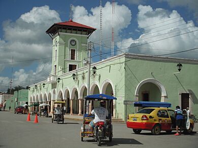
Maxcanú facts for kids
Maxcanú is a town in the western part of Yucatán, a state in Mexico. It is also the main town for the surrounding area, called the Maxcanú Municipality. You can find it about 62 kilometers (about 38 miles) south of a bigger city called Mérida.
Maxcanú is close to some really old and interesting places. These include the ancient Maya city of Oxkintok and the Calcehtok caves. Another old Maya settlement, Chunchucmil, is about 25 kilometers (15 miles) west of the town.
Contents
What Can You Find in Maxcanú?
Maxcanú has many useful places for people living there or visiting. You can find places to use the internet, grocery stores, and a market for fresh fruits and vegetables. There are also family restaurants and public phones. If you need tools or building supplies, there are hardware stores too.
For travel, Maxcanú has a bus station where you can catch buses to Mérida and Campeche. There are also "combi" taxis, which are shared vans that take people to nearby villages. The Maxcanú railway station for the new Tren Maya train is just outside of town.
Where is Maxcanú Located?
Maxcanú is located on Federal Highway 180. This highway connects it to other important cities. As mentioned, it is about 62 kilometers (38 miles) south of Mérida.
What's the Weather Like in Maxcanú?
| Climate data for Maxcanú | |||||||||||||
|---|---|---|---|---|---|---|---|---|---|---|---|---|---|
| Month | Jan | Feb | Mar | Apr | May | Jun | Jul | Aug | Sep | Oct | Nov | Dec | Year |
| Mean daily maximum °C (°F) | 29.7 (85.5) |
31.4 (88.5) |
34.1 (93.4) |
35.9 (96.6) |
36.7 (98.1) |
35.5 (95.9) |
35 (95) |
34.6 (94.3) |
33.8 (92.8) |
32 (90) |
31.0 (87.8) |
29.6 (85.3) |
33.3 (91.9) |
| Mean daily minimum °C (°F) | 16.2 (61.2) |
17.3 (63.1) |
19.1 (66.4) |
21.0 (69.8) |
22.4 (72.3) |
22.7 (72.9) |
22.4 (72.3) |
22.0 (71.6) |
22.0 (71.6) |
20.9 (69.6) |
18.8 (65.8) |
17.3 (63.1) |
20.2 (68.4) |
| Average precipitation mm (inches) | 28 (1.1) |
28 (1.1) |
18 (0.7) |
25 (1) |
110 (4.5) |
170 (6.7) |
160 (6.4) |
170 (6.7) |
190 (7.6) |
120 (4.7) |
48 (1.9) |
41 (1.6) |
1,120 (43.9) |
| Source: Weatherbase | |||||||||||||
Maxcanú has a warm climate throughout the year. The hottest months are usually April, May, and June, when temperatures can reach over 95 degrees Fahrenheit (35 degrees Celsius). The cooler months are December and January, but it's still quite warm. Maxcanú gets a lot of rain, especially from May to October.
Famous People from Maxcanú
Maxcanú is the hometown of Alfredo Barrera Vásquez. He was a very important Mexican expert who studied the Maya people and their culture. He was the main editor for a very important dictionary called the Diccionario Maya Cordemex. This dictionary helps people understand the Maya language and how to write it.
See also
 In Spanish: Maxcanú para niños
 | Sharif Bey |
 | Hale Woodruff |
 | Richmond Barthé |
 | Purvis Young |


