May Corner, Wisconsin facts for kids
Quick facts for kids
May Corner, Wisconsin
|
|
|---|---|
 |
|
| Country | |
| State | |
| County | Marinette |
| Elevation | 199 m (653 ft) |
| Time zone | UTC-6 (Central (CST)) |
| • Summer (DST) | UTC-5 (CDT) |
| Area code(s) | 715 & 534 |
| GNIS feature ID | 1569142 |
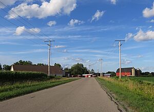
May Corner is a small place in Wisconsin, United States. It's known as an unincorporated community. This means it's a group of homes or buildings that don't have their own local government, like a city or town. Instead, it's part of a larger area called a town, which is Grover. May Corner is located in Marinette County.
Where is May Corner?
May Corner is about 5 miles (8 kilometers) west of a town called Peshtigo. You can find it where two roads, Town Hall Road and Church Road, meet. The land here is about 653 feet (199 meters) above sea level.
A small stream called Bundy Creek flows through May Corner. This creek eventually joins the Peshtigo River. May Corner is also connected to bigger roads. It's near a frontage road for U.S. Route 41 to the east. You can also reach it from County Trunk Highway M to the south and County Trunk Highway W to the west.
Close by, you'll find the Grover town hall to the west. The Grover Community Church is also located to the south of May Corner.
How May Corner Got Its Name
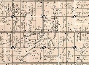
May Corner is named after a family farm that used to be there. This farm belonged to the May family and was located on the south side of the main intersection.
The farm was first owned by Sam G. May, who lived from 1839 to 1910. Later, his wife, Janet "Jennie" May, took over the farm. She was born Janet McFarlane and lived from 1853 to 1926. The community became known as May Corner because of their family farm.
 | Jackie Robinson |
 | Jack Johnson |
 | Althea Gibson |
 | Arthur Ashe |
 | Muhammad Ali |


