
Mayfield, Pennsylvania facts for kids
Quick facts for kids
Mayfield, Pennsylvania
|
||
|---|---|---|
|
Borough
|
||
 |
||
|
||

Location of Mayfield in Lackawanna County, Pennsylvania.
|
||

Mayfield, Pennsylvania
Location in Pennsylvania

Mayfield, Pennsylvania
Location in the United States
|
||
| Country | United States | |
| State | Pennsylvania | |
| County | Lackawanna | |
| Area | ||
| • Total | 2.45 sq mi (6.34 km2) | |
| • Land | 2.45 sq mi (6.34 km2) | |
| • Water | 0.00 sq mi (0.00 km2) | |
| Elevation | 1,004 ft (306 m) | |
| Population
(2020)
|
||
| • Total | 1,763 | |
| • Density | 720.77/sq mi (278.24/km2) | |
| Time zone | UTC-5 (EST) | |
| • Summer (DST) | UTC-4 (EDT) | |
| ZIP Code |
18433
|
|
| Area code(s) | 570 | |
| FIPS code | 42-48176 | |

Mayfield is a small town, called a borough, in Lackawanna County, Pennsylvania. It's about 14 miles (22.5 km) northeast of a bigger city called Scranton. Long ago, Mayfield was known for its silk factory and for mining coal. In 2020, about 1,763 people lived there.
Contents
Where is Mayfield Located?
Mayfield is found at specific coordinates: 41.538331 degrees North and 75.536554 degrees West. This helps us pinpoint its exact spot on a map.
Mayfield's Size and Land
According to the United States Census Bureau, Mayfield covers an area of about 2.4 square miles (6.3 square kilometers). All of this area is land, meaning there are no large lakes or rivers within its borders.
Who Lives in Mayfield?
This section shares information about the people who live in Mayfield, like how many there are and their ages.
Population Changes Over Time
The number of people living in Mayfield has changed quite a bit over the years. Here's a look at the population from different census counts:
| Historical population | |||
|---|---|---|---|
| Census | Pop. | %± | |
| 1890 | 1,695 | — | |
| 1900 | 2,300 | 35.7% | |
| 1910 | 3,662 | 59.2% | |
| 1920 | 3,832 | 4.6% | |
| 1930 | 3,774 | −1.5% | |
| 1940 | 3,172 | −16.0% | |
| 1950 | 2,373 | −25.2% | |
| 1960 | 1,996 | −15.9% | |
| 1970 | 2,176 | 9.0% | |
| 1980 | 1,812 | −16.7% | |
| 1990 | 1,890 | 4.3% | |
| 2000 | 1,756 | −7.1% | |
| 2010 | 1,807 | 2.9% | |
| 2020 | 1,763 | −2.4% | |
| 2021 (est.) | 1,756 | −2.8% | |
| Sources: | |||
Mayfield's Community in 2000
In the year 2000, there were 1,756 people living in Mayfield. These people made up 744 households, and 503 of those were families. On average, about 718 people lived in each square mile (277 people per square kilometer).
Most of the people in Mayfield were White (99.43%). A small number were African American, Native American, or Asian. About 0.40% of the population identified as Hispanic or Latino.
Households and Families
Out of the 744 households, about 26.1% had children under 18 living with them. More than half (51.6%) were married couples living together. About 12.1% were households where a female was the head of the house without a husband present.
Age Groups
The people in Mayfield were spread across different age groups.
- 20.0% were under 18 years old.
- 6.3% were between 18 and 24.
- 29.2% were between 25 and 44.
- 23.2% were between 45 and 64.
- 21.2% were 65 years or older.
The average age in Mayfield was 42 years old. For every 100 females, there were about 89 males.
Income Information
In 2000, the average income for a household in Mayfield was $30,074 per year. For families, the average income was $38,167. About 7.5% of all the people in Mayfield lived below the poverty line. This included 3.2% of those under 18 and 10.1% of those 65 or older.
Images for kids
-
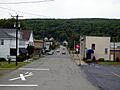
A view of Mayfield, Pennsylvania.
-

The flag of Mayfield, Pennsylvania.
-
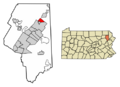
A map showing Mayfield's location in Lackawanna County, Pennsylvania.
See also
 In Spanish: Mayfield (Pensilvania) para niños
