Mazatán, Chiapas facts for kids
Quick facts for kids
Mazatán
|
|
|---|---|

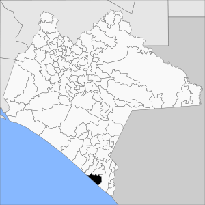
Municipality of Mazatán in Chiapas
|
|
| Country | |
| State | Chiapas |
| Area | |
| • Total | 147.7 sq mi (382.6 km2) |
| Population
(2010)
|
|
| • Total | 26,573 |
Villa Mazatán (Spanish pronunciation: [ˈβiʝa masaˈtan]) is a municipality in the Mexican state of Chiapas. It is located in southern Mexico. The area of Mazatán is about 386.6 square kilometers.
In 2010, the total population of the municipality was 26,573 people. The main town, also called Mazatán, had a population of 6,838. Other important towns included Buenos Aires (with 4,260 people), Marte R. Gómez (1,263 people), and Aquiles Serdán (1,135 people).
This area has a very long history. People have lived here for over 4,500 years, since about 2500 BC.
Contents
About Mazatán
The name Mazatán comes from two words in the ancient Náhuatl language. It means "place of many deer". This name was given because "Mazat" means "deer" and "tlan" means "place" or "earth".
The oldest signs of humans in Mazatán are called "chanchutos". These include fossil corn grains, pottery, and parts of old houses. They show that people lived here more than 5,000 years ago. Throughout history, the people of Mazatán have been farmers and fishers.
During the time of the Spanish conquest, Mazatán was part of Tuxtla Chico. Later, it became a part of the municipality of Tapachula. In 1942, Mazatán officially became its own municipality in Chiapas.
Compared to other parts of Chiapas, Mazatán's economy is mostly based on farming. Many people work in agriculture. Some people also move to nearby cities for work or education.
Mazatán is close to the border with Central America. Because of this, many people from countries like Guatemala and El Salvador come to work in the crop fields.
Ancient History of Mazatán
Mazatán has a rich history with several ancient civilizations.
Early Peoples: Mokaya and Olmec
The Mokaya people were among the first to live here. They started building important ceremonial centers around 2000 BC. They were also among the first to grow cacao (for chocolate) and rubber trees. They built mounds and platforms for their communities.
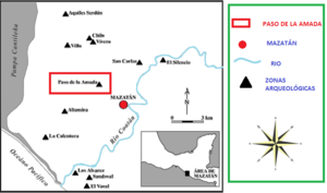
Paso de la Amada was an important early center for the Mokaya people. Another site from the same time was San Carlos.
Canton Corralito: An Ancient City
After Paso de la Amada, the site of Canton Corralito became very important. The Mokaya people lived here for a long time, from about 2500 BC to 1000 BC. Around 1000 BC, a big river flood destroyed Canton Corralito. It was covered by a thick layer of sand.
During this time, the Olmec people from another region started to interact with Canton Corralito. Some experts even called it "the Americas' First Colony" because of the strong Olmec influence. Many objects in the early Olmec style were found here, even more than in the Olmec heartland of San Lorenzo Tenochtitlán. This suggests a strong connection between the two areas.
Ojo de Agua: Pyramids and Planning
Later, the site of Ojo de Agua became very important. It is a large archaeological area within the Mazatán municipality. Ojo de Agua is special because it is the earliest known site in Mesoamerica to have pyramids built around open plazas.
This site was carefully planned. It covers about 200 hectares and dates back to 1200-1000 BC. The platform mounds are lined up in a specific way, pointing towards magnetic north. Many artifacts found here came from the Olmec region of San Lorenzo Tenochtitlán. Later, other sites like La Blanca and Ujuxte became more important than Ojo de Agua.
Modern History
In 1526, Mazatán became part of the Royal Order. In 1628, it was part of the church parish of Tuxtla Chico. By 1774, it was connected to Tapachula. Finally, in 1942, a governor's decision officially made Mazatán its own municipality.
|
See also
 In Spanish: Mazatán (Chiapas) para niños
 | George Robert Carruthers |
 | Patricia Bath |
 | Jan Ernst Matzeliger |
 | Alexander Miles |


