
McClellan–Kerr Arkansas River Navigation System facts for kids
Quick facts for kids McClellan–Kerr Arkansas River Navigation System |
|
|---|---|

Big Dam Bridge is a footbridge built atop the Murray Lock and Dam in Little Rock, Arkansas.
|
|
| Specifications | |
| Locks | 18 (originally 17) (Lock #11 was never constructed; Montgomery Point (Lock #99) was added after construction was completed) |
| Original number of locks | 17 |
| Navigation authority | Army Corps of Engineers |
| History | |
| Construction began | 1963 |
| Date of first use | January 1971 |
| Date completed | 1970 |
| Geography | |
| End point | Tulsa Port of Catoosa |
| Branch(es) | Arkansas Post Canal |


The McClellan–Kerr Arkansas River Navigation System (often called MKARNS) is a major water highway in the United States. It starts at the Tulsa Port of Catoosa in Oklahoma and travels southeast through Oklahoma and Arkansas until it reaches the mighty Mississippi River. This entire system is about 445 miles (716 km) long!
MKARNS was named after two important Senators, Robert S. Kerr from Oklahoma and John L. McClellan from Arkansas. They worked hard to get the project approved by Congress. The system officially opened on June 5, 1971, with President Richard M. Nixon attending the big ceremony. Today, the Army Corps of Engineers manages and operates this huge waterway.
Even though the system mainly follows the Arkansas River, it also includes parts of other rivers. These are the Verdigris River in Oklahoma and the White River in Arkansas. There's also a short man-made channel called the Arkansas Post Canal. This canal connects the Arkansas and White Rivers and is named after the nearby Arkansas Post National Memorial.
To make the Arkansas River deep enough for large boats, engineers built many dams. These dams create a series of deeper sections, like long lakes or reservoirs. This design helps boats travel smoothly, even though the river drops about 420 feet (128 meters) in height between the Mississippi River and the Tulsa Port of Catoosa. Along the MKARNS route, the river is used for big cargo barges, and also for people enjoying boat rides and other water activities.
Contents
Why This Waterway is Important
The U.S. Department of Transportation (USDOT) recognized the MKARNS as a very important "Corridor" on the National Marine Highway in 2015. This means it's a key route for moving goods by water. The Oklahoma Department of Transportation (ODOT) also became an official supporter of the system.
In the same year, the U.S. Army Corps of Engineers upgraded MKARNS to a "high-use waterway system." This special title means that the waterway carries more than 10 million tons of goods every year. That's a lot of cargo moving through Oklahoma and Arkansas!
Building the Waterway
The Arkansas River was naturally very shallow in many places. This meant it wasn't easy for boats to travel on it for most of the year. To fix this, construction began in 1963. The plan was to build a system of channels and special water elevators called locks. These would connect the many reservoirs along the Arkansas River.
The first part of the system, reaching Little Rock, Arkansas, opened on January 1, 1969. The very first large cargo boat, called a barge, arrived at the Port of Catoosa in early 1971.
How Locks Work
Each lock on the MKARNS is 110 feet (34 meters) wide and 600 feet (183 meters) long. This is a standard size for many waterways, including parts of the Mississippi River.
- Large groups of barges, called a tow, can fit into these locks.
- A standard jumbo barge is 35 feet (11 meters) wide and 195 feet (59 meters) long.
- Barge tows are often made of nine barges (three wide by three long) with a tugboat pushing from the back.
- If a barge tow is too big, it has to be split into smaller sections. Each section goes through the lock, and then they are put back together on the other side.
Channel Size
The waterway itself has specific sizes to allow boats to pass safely:
- The channel is usually 9 feet (2.7 meters) deep or more.
- The width of the channel is mostly between 250 feet (76 meters) and 300 feet (91 meters).
- Bridges over the waterway must be at least 300 feet (91 meters) wide horizontally.
- They also need to be at least 52 feet (16 meters) high vertically, so tall boats can pass underneath.
Congress once wanted to make the channel 12 feet (3.7 meters) deep in 2005. However, they didn't provide the money for it. Making the channel deeper would allow each barge to carry an extra 200 tons of cargo for every foot of added depth. In 2010, experts said that much of MKARNS was already 12 feet deep. Only about 75 miles (121 km) would need to be deepened. This project would have cost about $170 million back then.
Understanding the Locks and Dams
The McClellan–Kerr Arkansas River Navigation System has 18 locks and dams. These structures help boats move up and down the river, overcoming changes in elevation.
It's interesting to note that there is no Lock 11. It was originally planned to be in the middle of Lake Dardanelle. However, the Dardanelle Lock & Dam (Lock 10) and the Ozark-Jeta Taylor Lock & Dam (Lock 12) were redesigned. They were built higher and possibly in different spots. This change meant that Lock 11 was no longer needed. The Mississippi River lock is called Lock 99 because it was added after the main system was finished.
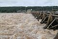
2019 Arkansas River Flooding
In May and June 2019, very heavy rains caused major flooding upstream of Keystone Dam. So much water flowed into the Keystone Reservoir that officials had to release a lot of water. This was done to prevent the dam from overflowing, which would have caused terrible floods downstream.
Even with the controlled release, a huge amount of water rushed down the MKARNS. The Corps of Engineers had to stop all barge traffic. This was to prevent accidents like boats crashing or hitting trees and other floating debris in the fast-moving water.
By October, barge traffic was allowed again, but only in a limited way. Normally, a tow might have twelve to sixteen barges. But the flood had left so much mud and sand in the river that it needed to be dredged again. Until then, tows were limited to six barges (two wide and three deep).
The 2019 flood dumped about 1.5 million cubic yards of sediment into the waterway. As of February 2020, barge traffic was still limited. Boats could only travel during daylight hours due to the sediment. The Corps expected to finish dredging the sediment by late May 2020.
How Waterway Traffic is Controlled
As more businesses use MKARNS, the locks can get very busy. To manage this, the Army Corps of Engineers has a set of rules for which boats get to use the locks first:
- Boats owned by the U.S. Government go first.
- Then come commercial passenger boats (like tour boats).
- Next are commercial vessels, such as barges carrying goods.
- After that, rafts are allowed.
- Finally, pleasure craft (like personal boats) can use the locks.
There's no minimum size for boats using the locks. Even small canoes, dinghies, and kayaks are allowed! They can go through alone or with other boats. If there's a lot of commercial traffic, pleasure boats might have to wait about 1.5 hours. Sometimes, they are allowed to go through the lock at the same time as commercial vessels.
Images for kids
-
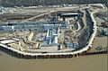
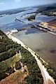
Montgomery Point Lock & Dam
August 25, 2005
USACE -
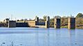
Norrell Lock and Dam, Arkansas.
-
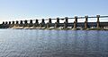
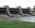
Wilbur D. Mills Dam.
-
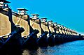
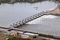
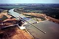
Joe Hardin Lock and Dam, Arkansas River.
-
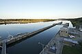
Murray Lock in Little Rock, Arkansas.
-
Dardanelle Lock and Dam (Lock 10).
-
W. D. Mayo Lock and Dam (Lock 14).
-
Aerial view of Robert S. Kerr Lock and Dam, impounding Robert S. Kerr Reservoir on the Arkansas River.
-
Webbers Falls Lock and Dam (Lock 16).
-
Chouteau Lock and Dam in Wagoner County, Oklahoma, August 23, 2007.
-
Newt Graham Lock and Dam on the Verdigris River in Wagoner County, Oklahoma.
-
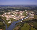
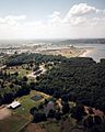
Aerial photo of the Tulsa Port of Catoosa taken May 5, 2008.


.jpg)


