McEwen, Oregon facts for kids
Quick facts for kids
McEwen, Oregon
|
|
|---|---|

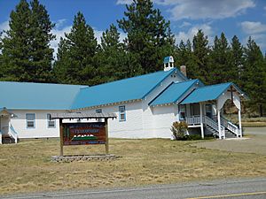
Community church in McEwen
|
|
| Country | United States |
| State | Oregon |
| County | Baker |
| Elevation | 4,150 ft (1,260 m) |
| Time zone | UTC-8 (Pacific (PST)) |
| • Summer (DST) | UTC-7 (PDT) |
| Area code(s) | 458 and 541 |
| GNIS feature ID | 1136524 |
McEwen is a small, unincorporated community in Baker County, Oregon, United States. An unincorporated community is a place that doesn't have its own local government.
Discovering McEwen
McEwen is located in eastern Oregon. It sits along the Powder River. This community is about 6 miles (10 km) southeast of another town called Sumpter. You can find McEwen if you travel on Oregon Route 7.
The History of McEwen
McEwen started as a busy logging town. Logging means cutting down trees for wood. The town was officially planned out in 1891.
Trains and the Town
McEwen also became a stop on the Sumpter Valley Railway. This was a special train line. It helped move logs and people through the area.
How McEwen Got Its Name
The community was named after a settler named Thomas McEwen. He claimed land in this area back in 1888. McEwen even had its own post office for many years. It opened in 1893 and closed in 1943.
 | James Van Der Zee |
 | Alma Thomas |
 | Ellis Wilson |
 | Margaret Taylor-Burroughs |


