Mechanicsville Historic District (Grafton, Vermont) facts for kids
Quick facts for kids |
|
|
Mechanicsville Historic District
|
|
 |
|
| Location | Vermont Route 121 E., Grafton, Vermont |
|---|---|
| Area | 56 acres (23 ha) |
| Architectural style | Federal, Greek Revival, Italianate, Vernacular |
| NRHP reference No. | 10000766 |
| Added to NRHP | September 16, 2010 |
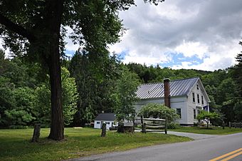
The Mechanicsville Historic District is a special area in Grafton, Vermont, with old houses that show what was once an important industrial part of the town. It's located a short distance east of Grafton Village on Vermont Route 121. This district includes ten well-preserved buildings from the 1800s, some of which are on land where old factories used to stand. This historic area was added to the National Register of Historic Places in 2010. This means it's officially recognized as an important place in American history.
Contents
Discovering Mechanicsville's Past
The area we now call Grafton was first set up in 1754, but people didn't start living there permanently until the late 1770s. Grafton Village grew up where two parts of the Saxtons River meet. Mechanicsville, which is a bit further down the river from Grafton Village, was one of the first places where important mills were built. These mills included grist mills (for grinding grain into flour) and lumber mills (for cutting wood).
Early Mills and Town Life
Three of Mechanicsville's lumber mills kept working into the 1900s, helping the local economy. The last one closed in the 1960s. Today, you won't see the mills, but you'll find many houses that were built in the early to mid-1800s. These homes tell the story of the people who lived and worked there long ago.
What You'll See in the District
The historic district has twelve houses in total, and ten of them are considered historically important. Seven of these houses are on the north side of Route 121, near the Howland Mill Bridge. The other five are west of the bridge, between the road and the river. Most of the houses are built close to the road.
Many of these homes show simple versions of popular building styles from the past, like the Federal and Greek Revival styles. There's also one house that shows the Italianate style, which was popular a bit later.
Changes Over Time
Two properties in the district are not considered "contributing" to its historical importance. One is a newer house built in the 2000s in a style called Colonial Revival. The other is an old blacksmith's shop from the 1800s that was moved and turned into a home.
Sadly, in 2011, a house known as the "Chipmunk House" (which was an old blacksmith's shop) was washed away by Hurricane Irene. This left eleven houses in the district, with nine of them being historically important. A metal guardrail now stands where the Chipmunk House used to be, just west of the Howland Mill Bridge.
Images for kids
 | Isaac Myers |
 | D. Hamilton Jackson |
 | A. Philip Randolph |


