Medford, Maine facts for kids
Quick facts for kids
Medford, Maine
|
|
|---|---|

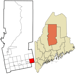
Location in Piscataquis County and the state of Maine.
|
|
| Country | United States |
| State | Maine |
| County | Piscataquis |
| Area | |
| • Total | 43.16 sq mi (111.78 km2) |
| • Land | 42.31 sq mi (109.58 km2) |
| • Water | 0.85 sq mi (2.20 km2) |
| Elevation | 328 ft (100 m) |
| Population
(2020)
|
|
| • Total | 230 |
| • Density | 5/sq mi (2.1/km2) |
| Time zone | UTC-5 (Eastern (EST)) |
| • Summer (DST) | UTC-4 (EDT) |
| ZIP code |
04463
|
| Area code(s) | 207 |
| FIPS code | 23-44830 |
| GNIS feature ID | 0582589 |
Medford is a small town located in Piscataquis County, Maine, in the United States. In 2020, about 230 people lived there. It is a quiet place with a history tied to the forests and rivers of Maine.
History of Medford
The first white settler in the area that is now Medford was James Grover. He arrived in 1808. In 1820, the state built a road from the Piscataquis River. This road helped more people move to the area.
In 1820, a man named John Parker Boyd owned the eastern part of the town. He built a mill on the Piscataquis River. This mill could cut both lumber and shingles. In 1824, the town officially became a town. It was named Kilmarnock, a name chosen by Boyd.
A big fire happened in 1825. It destroyed more than three-quarters of the buildings in town. It also burned down many pine trees nearby. These trees were used to supply the mill. The mill itself was saved from the fire. However, it later closed because there were no more trees to cut.
The people of Kilmarnock asked to change the town's name to Medford in 1856. The town gave up its official town status in 1940. It then became a plantation in 1942. A plantation is a type of small community in Maine. In 1967, Medford became an official town again.
Geography of Medford
Medford is located in the state of Maine. The United States Census Bureau measures the size of towns. They say that Medford covers a total area of about 43.16 square miles (111.78 square kilometers).
Most of this area is land. About 42.31 square miles (109.58 square kilometers) is land. The rest is water. About 0.85 square miles (2.20 square kilometers) is water.
Population and People
| Historical population | |||
|---|---|---|---|
| Census | Pop. | %± | |
| 1860 | 353 | — | |
| 1870 | 294 | −16.7% | |
| 1880 | 398 | 35.4% | |
| 1890 | 306 | −23.1% | |
| 1900 | 282 | −7.8% | |
| 1910 | 262 | −7.1% | |
| 1920 | 228 | −13.0% | |
| 1930 | 251 | 10.1% | |
| 1940 | 213 | −15.1% | |
| 1950 | 191 | −10.3% | |
| 1970 | 146 | — | |
| 1980 | 163 | 11.6% | |
| 1990 | 194 | 19.0% | |
| 2000 | 231 | 19.1% | |
| 2010 | 254 | 10.0% | |
| 2020 | 230 | −9.4% | |
| U.S. Decennial Census | |||
The number of people living in Medford changes over time. In 2010, there were 254 people living in the town. This means there were about 6 people for every square mile of land.
Most of the people living in Medford are White. A very small number of people are African American or from two or more races.
Images for kids
See also
 In Spanish: Medford (Maine) para niños


