Memphis Parkway System facts for kids
Quick facts for kids |
|
|
Memphis Park and Parkway System
|
|

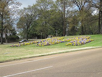
The Memphis "M" is located on the median of East Parkway at Madison Avenue. Historically, this area was the location of the Sunken Garden in the 1930s.
|
|
| Location | Memphis, Tennessee |
|---|---|
| Built | 1903 |
| NRHP reference No. | 89000520 |
| Added to NRHP | July 3, 1989 |
The Memphis Parkway System is a group of special roads that form a large circle around Memphis, Tennessee. People in Memphis often call them "The Parkways." This system includes South Parkway, East Parkway, and North Parkway.
A famous designer named George Kessler created the Parkway System. It connects two important parks: Martin Luther King Jr. Riverside Park and Overton Park. Because of its history and design, the system was added to the National Register of Historic Places on July 3, 1989. This means it's recognized as a special historical place.
History of the Parkways
Around the late 1800s, Memphis faced big challenges, including a yellow fever outbreak. To make the city better, leaders decided to improve things like sewer systems and public services. They also wanted to create a network of parks connected by beautiful roads.
In 1897, the city started adding new land, including areas that would become these parks. They bought this land in 1901. That same year, the city chose George Kessler to design the new plan. Work on Overton Park began in 1902 and finished quickly. Work on Martin Luther King Jr. Riverside Park also started in 1902 and was done by 1903.
Building the Parkway System itself began in 1904. There was a delay because of a lawsuit. Some people thought the government was unfairly taking private land for public use. This is called eminent domain. However, the Tennessee Supreme Court decided the city was allowed to do this.
Instead of winding roads, Kessler designed a rectangular border around the city. He even used some existing streets. South Parkway and East Parkway were built first. North Parkway was once called Summer Avenue and also Speedway. Kessler originally designed parts of the parkways for people to race their cars and carriages! But in 1910, Memphis stopped this practice. They put a speed limit on the entire system. You can still see a hint of this racing past in the name of the Speedway Terrace Historical District today.
The entire Parkway System was finished in 1906. After it was built, more homes and businesses grew up along its route. Many other cities in Tennessee looked at Memphis's park and parkway system as a good example for their own city planning. For many years, the Parkway System marked the edge of Memphis. It is still a very important road system in the city today.
What the Parkway System Looks Like
Let's take a trip around the Parkway System, starting from the southwest corner.
The system begins at Martin Luther King Jr. Riverside Park. It crosses over Interstate 55. This first part, called South Parkway West, has four lanes and no trees in the middle. It goes through an industrial area.
After crossing Interstate 240/Interstate 69, the road becomes South Parkway East. Here, it changes! It becomes divided with a beautiful, wooded area in the middle, just like most of the parkways.
South Parkway then turns into East Parkway South. It passes U.S. Highway 78 (Lamar Avenue). East Parkway South continues north. It goes under Union Avenue and then becomes East Parkway North. At this point, it picks up several U.S. highways like U.S. Highway 64 and U.S. Highway 70. When it passes Poplar Avenue, it goes east of Overton Park and meets Sam Cooper Boulevard.
When East Parkway meets North Parkway, it loses some of its highway names. North Parkway then picks up the State Route 1 designation. This is one of the few places in Tennessee where you'll see this specific state route sign. North Parkway continues west, crosses Interstate 40, and ends at U.S. Highway 51. The road keeps going west as A.W. Willis Avenue, crossing the Wolf River, and finally ending on Mud Island.
Most of the Parkway System has a wide area in the middle, called a median. This median is full of large, old trees and sometimes has pretty flowers. South Parkway has two lanes in each direction. Parts of it also have lanes for bikes or parking. East Parkway usually has three lanes in each direction. North Parkway used to have three lanes in each direction, but bike and parking lanes were added in the mid-2010s. The speed limit for the entire system is forty miles per hour.
Famous Places Near the Parkways
Here are some interesting places you can find close to the parkways:
South Parkway Section
- President's Island / McKellar Lake
- M.L.K. Riverside Park
East Parkway Section
- Cooper-Young, Memphis
- Christian Brothers University
- Children's Museum of Memphis
- Mid-South Coliseum
- Liberty Bowl Memorial Stadium
- Memphis Theological Seminary
- Memphis Brooks Museum of Art
- Overton Park
North Parkway Section
- Memphis Zoo
- Rhodes College
- St. Jude Children's Research Hospital
- Pyramid Arena
 | Dorothy Vaughan |
 | Charles Henry Turner |
 | Hildrus Poindexter |
 | Henry Cecil McBay |


