Mesquite, New Mexico facts for kids
Quick facts for kids
Mesquite, New Mexico
|
|
|---|---|

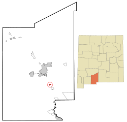
Location of Mesquite, New Mexico
|
|
| Country | United States |
| State | New Mexico |
| County | Dona Ana |
| Area | |
| • Total | 0.82 sq mi (2.12 km2) |
| • Land | 0.82 sq mi (2.12 km2) |
| • Water | 0.00 sq mi (0.00 km2) |
| Elevation | 3,839 ft (1,170 m) |
| Population
(2020)
|
|
| • Total | 984 |
| • Density | 1,201.47/sq mi (463.96/km2) |
| Time zone | UTC-7 (Mountain (MST)) |
| • Summer (DST) | UTC-6 (MDT) |
| ZIP code |
88048
|
| Area code(s) | 575 |
| FIPS code | 35-48270 |
| GNIS feature ID | 2408823 |
Mesquite is a small community in Doña Ana County, New Mexico, United States. It is called a census-designated place (CDP). This means it is a place the government counts for population, but it is not officially a city or town with its own local government.
In 2020, about 984 people lived in Mesquite. It is part of the larger Las Cruces area.
Contents
History of Mesquite
Mesquite got its name from the Santa Fe Railroad. The people who ran the railroad saw many mesquite bushes growing along the tracks. These tough desert plants were already a big part of the area's landscape.
In 1847, a group of soldiers left El Paso, Texas. They were on a trip to find the Apaches. On their journey, some soldiers got lost in the thick mesquite plants. When they found their way back, their leader told them to set up camp. He made sure they were ready for the next day's travel.
Geography and Location
Mesquite is in the southeastern part of Doña Ana County. It sits in the Mesilla Valley, which is on the east side of the Rio Grande river.
Interstate 10 runs just east of Mesquite. You can get to Mesquite from Exit 151. If you go northwest on I-10 for about 13 miles (21 km), you will reach Las Cruces. Las Cruces is the main city in the county. If you go southeast on I-10 for about 35 miles (56 km), you will get to El Paso, Texas.
The United States Census Bureau says that Mesquite is about 0.82 square miles (2.1 square kilometers) in total area. All of this area is land.
People of Mesquite
| Historical population | |||
|---|---|---|---|
| Census | Pop. | %± | |
| 2020 | 984 | — | |
| U.S. Decennial Census | |||
In 2000, there were 948 people living in Mesquite. There were 262 households, and 227 of these were families. The population density was about 1,148 people per square mile (443 people per square kilometer).
Most people in Mesquite are of Hispanic or Latino background. In 2000, about 94.8% of the people identified as Hispanic or Latino.
Many households in Mesquite had children under 18 living with them. About 65.3% of households were married couples. The average household had about 3.6 people.
The population of Mesquite is quite young. In 2000, about 38.1% of the people were under 18 years old. The average age was 24 years.
Education in Mesquite
Students in Mesquite attend public schools run by the Gadsden Independent School District.
- Mesquite Elementary School is the local elementary school.
- For high school, students usually go to Gadsden High School or Alta Vista Early College High School.
See also
 In Spanish: Mesquite (Nuevo México) para niños
 | James Van Der Zee |
 | Alma Thomas |
 | Ellis Wilson |
 | Margaret Taylor-Burroughs |

