Milecastle 14 facts for kids
Quick facts for kids Milecastle 14 |
|
|---|---|
| Northumberland, England, UK | |

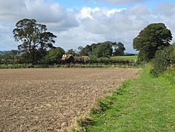
The site of Milecastle 14
|
|
|
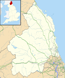
Location in Northumberland
|
|
| Coordinates | 55°00′13″N 1°49′59″W / 55.003682°N 1.833018°W |
Milecastle 14 (March Burn) was a small fort, called a milecastle, built by the Romans. It was part of Hadrian's Wall, a huge stone wall that stretched across northern England. This wall was built to protect the Roman Empire from tribes to the north.
Milecastle 14 is located in Northumberland, England. Today, you can still see its remains as a low platform. It's about 0.4 meters (1.3 feet) high on its west side. You can find it south of the B6318 Military Road. It is also about 1 kilometer (0.6 miles) west of Rudchester Farm.
Contents
Building Milecastle 14
Milecastle 14 was a special type of milecastle. It was built with its shorter side facing the wall. The Romans built these small forts in a very organized way. Each milecastle had two gates. One gate faced north towards the enemy. The other gate faced south towards the Roman lands.
The builders of Milecastle 14 were likely soldiers from the Legio II Augusta. This Roman legion was based in a place called Isca Augusta, which is now Caerleon in Wales.
Milecastle 14 was about 18.29 meters (60 feet) wide. It had strong, thick walls. Inside the milecastle, there was at least one building. The remains of this building were found on the west side. It was about 5.11 meters (16.8 feet) wide.
Discovering Milecastle 14
People have studied Milecastle 14 for many years. They want to learn more about how the Romans lived and worked there.
Early Discoveries
- 1930: The first signs of Milecastle 14 were seen from an airplane. The low platform of the milecastle was visible in an aerial photograph.
- 1946: A researcher named Stevens looked closely at the milecastle. He measured its size and checked the condition of the north gate. He found that the north gate had been blocked up sometime after it was built. Sadly, any signs of the south gate had been destroyed by farming over the years.
Later Investigations
- 1966: A group called English Heritage did a field investigation. They confirmed what Stevens had found earlier.
- 1989: English Heritage did another investigation. This time, they did not find any new information about the milecastle.
Nearby Watchtowers
Every milecastle along Hadrian's Wall had two smaller watchtowers. These towers were called turrets. They were placed about one-third and two-thirds of a Roman mile to the west of the milecastle. Soldiers from the milecastle would have guarded these turrets. The turrets linked to Milecastle 14 are called Turret 14A and Turret 14B.
Turret 14A
Today, you cannot see any remains of Turret 14A (Eppies Hill). However, in 1966, during an English Heritage investigation, a lot of stones were found. They were in a field hedge on top of a hill. This might be where the turret once stood. An old writer named Horsley also said he saw the turret, but his notes are not very clear about its exact spot.
Approximate location: 55°00′13″N 1°50′37″W / 55.003741°N 1.843555°W
Turret 14B
No signs of Turret 14B have ever been found. Its exact location is still a mystery.
Expected location: 55°00′16″N 1°50′56″W / 55.004493°N 1.848977°W
 | William L. Dawson |
 | W. E. B. Du Bois |
 | Harry Belafonte |


