Milecastle 20 facts for kids
Quick facts for kids Milecastle 20 |
|
|---|---|

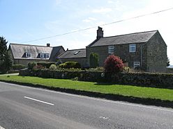
Milecastle 20 is thought to lie beneath these houses in the hamlet of Halton Shields
|
|
| Type | Milecastle |
| Location | |
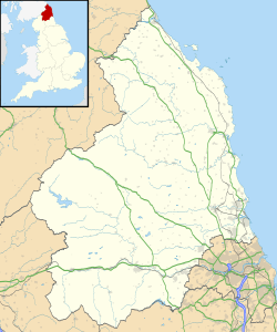
| Coordinates | 55°00′46″N 1°58′19″W / 55.012716°N 1.972057°W |
| County | Northumberland |
| Country | England |
Milecastle 20 (Halton Shields) was one of the many small forts built along Hadrian's Wall. This famous wall was built by the Romans across northern England. It helped protect their lands from tribes living to the north. Milecastles were like mini-forts placed about one Roman mile apart. They usually had gates that allowed people to pass through the wall. Milecastle 20 is located in a small village called Halton Shields. Today, you cannot see any parts of this milecastle above the ground.
Contents
What Was Milecastle 20 Like?
Milecastle 20 was located at the eastern end of Halton Shields. Most of its remains are now under the garden of a house. The southern wall and gate of the milecastle are even covered by a house next door.
In 1879, an old drawing of the Military Road showed some large stone blocks. These blocks looked like they were the pivot stones from the milecastle's main gateway. Pivot stones are what the gate doors would have turned on. There were also threshold blocks, which formed the bottom part of the doorway.
When Was Milecastle 20 Explored?
Archaeologists dug up Milecastle 20 in 1935. They found that it was about 17.7 meters long and 16.3 meters wide. It had a special kind of gate known as a Type III gateway. This tells us about how the Romans built their forts.
What Were the Turrets Near Milecastle 20?
Every milecastle on Hadrian's Wall had two smaller watchtowers nearby. These towers are called turrets. They were placed about one-third and two-thirds of a Roman mile to the west of each milecastle. Soldiers from the milecastle would have guarded these turrets. The turrets connected to Milecastle 20 are known as Turret 20A and Turret 20B.
Turret 20A (Carr Hill)
Turret 20A (Carr Hill) is now covered by a modern road. Because of this, its exact location is not fully known. Archaeologists believe they found its spot in 1935 by finding pieces of old Roman pottery.
Turret 20B (Downhill East)
Turret 20B (Downhill East) is also covered by a modern road. Its precise location is also uncertain, just like Turret 20A.
Were There Roman Camps Nearby?
About 350 meters south of Milecastle 20, there are signs of two possible Roman temporary camps. These camps can be seen from aerial photographs as faint earthworks. Earthworks are changes in the shape of the land.
The more complete camp looks like a low bank with two rounded corners. A second, less clear camp is located to the north-east of the first one. These temporary camps were likely used by Roman soldiers when they were marching or building the wall.
How Do We Keep Track of These Sites?
Historians and archaeologists keep records of important historical sites. Here are the official numbers for Milecastle 20 and its nearby turrets and camps:
| Monument | Monument Number | English Heritage Archive Number |
| Milecastle 20 | 20464 | NZ 06 NW 7 |
| Turret 20A | 20467 | NZ 06 NW 8 |
| Turret 20B | 20470 | NZ 06 NW 9 |
| Roman temporary camps | 1433441 | NZ 06 NW 149 |
 | Janet Taylor Pickett |
 | Synthia Saint James |
 | Howardena Pindell |
 | Faith Ringgold |


