Milecastle 36 facts for kids
Quick facts for kids Milecastle 36 |
|
|---|---|

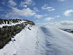
The summit of King's Hill near the site of Milecastle 36
|
|
| Type | Milecastle |
| Location | |
| Coordinates | 55°01′05″N 2°19′07″W / 55.017963°N 2.318619°W |
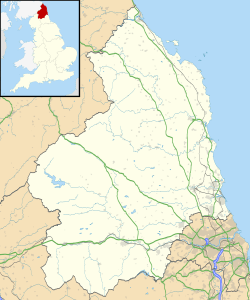
| County | Northumberland |
| Country | England |
Milecastle 36 (King's Hill) was a small fort, or "milecastle," built along Hadrian's Wall in ancient Roman times. These milecastles were like mini-forts placed every Roman mile along the wall. Today, there isn't much left to see at Milecastle 36. Most of its stone was taken away long ago to be used for other buildings.
Contents
What is Milecastle 36?
Milecastle 36 is located on a place called King's Hill. This spot is about 800 metres northeast of a larger Roman fort called Housesteads Roman Fort. Imagine a small guard post on a hill, watching over the land.
Sadly, much of the stone from Milecastle 36 was removed in 1831. This means people took the stones to build other things. You can still see where the east and west walls used to be. These are marked by "robber-trenches," which are ditches left behind when stones were dug up. The rest of the milecastle has been damaged by quarrying, where stone was dug out of the ground. The inside of the milecastle is now mostly covered by fallen stones from the Wall itself.
Digging Up the Past: Excavations
Archaeologists, who are like history detectives, dug up Milecastle 36 in 1946. They found that it was built with a longer main path and narrower walls. This was a common design for some milecastles.
The excavations also showed interesting changes over time. After the time of Emperor Hadrian, the south gate of the milecastle was destroyed. The north gate was rebuilt, but then it was blocked up. This suggests that the way the milecastle was used changed over the years.
Milecastle Companions: Associated Turrets
Every milecastle along Hadrian's Wall had two smaller watchtowers, called turrets, connected to it. These turrets were placed about one-third and two-thirds of a Roman mile to the west of the milecastle. Soldiers from the nearby milecastle would likely have guarded these turrets. For Milecastle 36, these watchtowers were called Turret 36A and Turret 36B.
Turret 36A (Kennel Crags)
Turret 36A, also known as Kennel Crags, can only be seen as a small raised area of earth today. This turret was first found in 1911 and then dug up by archaeologists in 1946. They discovered it had narrow walls and a doorway facing east. It seems this turret was no longer used before the Roman period ended.
Turret 36B (Housesteads)
Turret 36B, known as Housesteads, is actually located inside the larger Housesteads Roman Fort. When the fort was built, this turret was taken down and new buildings were put on top of it. However, the original foundations of the turret still exist. Archaeologists have dug up and strengthened these foundations. They now stand up to 0.7 metres high, showing where the turret once stood within the fort.
Finding Out More: Monument Records
Historians and archaeologists keep records of important sites like these. Here are the official numbers for Milecastle 36 and its turrets:
| Monument | Monument Number | English Heritage Archive Number |
| Milecastle 36 | 15137 | NY 76 NE 2 |
| Turret 36A | 15140 | NY 76 NE 3 |
| Turret 36B | 15143 | NY 76 NE 4 |
Visiting These Historic Sites
You can visit Milecastle 36 and the site of Turret 36A by walking along the Hadrian's Wall Path. This is a long walking trail that follows the route of the ancient wall. The foundations of Turret 36B are inside Housesteads Fort. To see them, you need to visit the fort, which is managed by English Heritage.
 | Ernest Everett Just |
 | Mary Jackson |
 | Emmett Chappelle |
 | Marie Maynard Daly |


