Milecastle 69 facts for kids
Quick facts for kids Milecastle 69 |
|
|---|---|

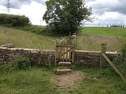
Sourmilk Bridge (close to the site of Milecastle 69)
|
|
| Type | Milecastle |
| Location | |
| Coordinates | 54°54′49″N 2°59′27″W / 54.913694°N 2.990897°W |
| County | Cumbria |
| Country | England |
Milecastle 69 (Sourmilk Bridge) was one of many small forts called milecastles. These were built along Hadrian's Wall by the Romans. Each milecastle was placed about one Roman mile apart. They helped guard the wall and control who passed through.
What is Milecastle 69?
Milecastle 69 is believed to be located near the village of Grinsdale. This village is part of Beaumont in Cumbria, England. The exact spot of this milecastle has not yet been found by archaeologists.
It is thought to be somewhere between Sourmilk Bridge and the buildings of Park Farm. This area is just west of Grinsdale. In 1858, some old foundation stones were seen near Sourmilk Bridge. However, these stones might have come from an old mill that was once there.
Turrets of Milecastle 69
Every milecastle on Hadrian's Wall had two smaller watchtowers called turrets. These turrets were placed about one-third and two-thirds of a Roman mile to the west of the milecastle. Soldiers from the milecastle would have guarded these turrets.
The turrets connected to Milecastle 69 are known as Turret 69A and Turret 69B. Their exact locations are not known for sure. This is because many turrets in this area were not looked for until after 1961.
Turret 69A is probably located halfway between Sourmilk Bridge and where Holme Lane gets closest to the Wall. Turret 69B is thought to be under the site of St Andrew's Church. This church is in the village of Kirkandrews-on-Eden.
 | Roy Wilkins |
 | John Lewis |
 | Linda Carol Brown |


