
Milecastle 70 facts for kids
Quick facts for kids Milecastle 70 |
|
|---|---|

Milecastle 70 lay next to the River Eden between Kirkandrews and Beaumont
|
|

Location in the City of Carlisle district

Location in Cumbria
|
|
| Type | Milecastle |
| Location | |
| Coordinates | 54°55′17″N 3°00′48″W / 54.921328°N 3.01324°W |
| County | Cumbria |
| Country | England |
Milecastle 70 (Braelees) was a small fort built by the Romans. It was part of a series of these forts. They were placed about one Roman mile apart along Hadrian's Wall.
Contents
What is Milecastle 70?
Milecastle 70 is believed to be located near the villages of Kirkandrews-on-Eden and Beaumont. This spot is close to the River Eden. However, its exact location has not yet been found.
In 2000, a special survey was done to find it. This survey uses tools to look underground without digging. But it could not locate the milecastle. It might be that most of its stones were taken away long ago. People often reused Roman stones for other buildings.
Traces of the Past
Even though the milecastle is hard to find, other Roman signs are nearby. Experts believe they found the line of Hadrian's Wall close to where the milecastle should be.
At a place called Braelees, many cut stones were found in a garden. A gardener dug them up and used them for a rockery. These stones are thought to be from the Wall.
North of the site, parts of the Wall's ditch can still be seen. This ditch was a defense for the Wall. It is about 2 meters deep in some places.
Roman Discoveries
Over the years, several Roman items have been found in this area. In the early 1800s, a piece of a Roman stone was found in the River Eden. This stone was put into a wall in Beaumont. It was a special stone that honored the work of the Fifth Cohort of the Twentieth Legion. A cohort was a large group of Roman soldiers.
In 1934, a Roman altar was discovered. It was found when an old cottage in Beaumont was being taken down. An altar was a stone used for religious offerings. This one was dedicated to Jupiter, a main Roman god. It also honored the spirit of a group of soldiers called the Aurelian Moors.
A Roman coin was also found by a gardener at Braelees in 1935. These finds help us learn more about the Romans who lived here.
Nearby Turrets
Each milecastle on Hadrian's Wall had two smaller watchtowers, called turrets. These turrets were placed about one-third and two-thirds of a Roman mile to the west of the milecastle. Soldiers from the milecastle would have guarded these turrets.
The turrets linked to Milecastle 70 are called Turret 70A and Turret 70B. Their exact locations are not certain.
Turret 70A
There are no visible signs of Turret 70A on the ground. It is thought to be located under a medieval castle mound in Beaumont. This type of castle mound is called a motte. In 1928, some digging in the churchyard nearby found proof of Hadrian's Wall buried there.
Turret 70B
Turret 70B is expected to be about 540 meters west of St Mary's Church. It is south of a road called Milldikes Lane. In 1858, someone noted a "green spot" near a pond in this area. This green spot was still visible in 1961.
Images for kids
-
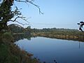
Milecastle 70 lay next to the River Eden between Kirkandrews and Beaumont
