
Milefortlet 10 facts for kids
Quick facts for kids Milefortlet 10 |
|
|---|---|

Milefortlet 10 probably lay by the coast between Skinburness and Silloth
|
|

Location in Allerdale

Location in Cumbria
|
|
| Type | Milecastle |
| Location | |
| Coordinates | 54°53′02″N 3°22′30″W / 54.883801°N 3.375039°W |
| County | Cumbria |
| Country | England |
Milefortlet 10 (East Cote) was likely a small Roman fort along the coast of Cumbria, England. It was part of a defense system built by the Roman Empire at the same time as Hadrian's Wall. However, there is no real proof that Milefortlet 10 ever existed. Experts believe it was there based on how far apart other Roman forts were.
Contents
Building the Fort
We don't know much about how Milefortlet 10 might have been built. It's possible that any remains of the fort were washed away by the sea. This could have happened because of coastal erosion, which is when the land near the sea slowly wears away. This might have happened after a pier was built in Silloth in 1855.
Searching for the Fort
Over the years, people have looked for Milefortlet 10, but they haven't found any clear signs of it.
Early Visits and Surveys
- 1949 - A person named J. K. St Joseph visited the area to look for the fort.
- 1955 - English Heritage, a group that protects historical sites, did an investigation. They saw a small raised area, like a bank, about 0.2 meters high. It also looked like it had a rounded corner. But they didn't map it out.
Digging for Clues
- 1991 - People dug trenches where the fort was thought to be. They found layers of natural sand, which looked like sand dunes. These dunes probably formed at two different times, with gravel from floods in between. They realized the raised area seen earlier was just a sand dune, like many others nearby.
- 1992 - The area was built over. No Roman remains were found during this construction.
Nearby Roman Towers
Each milefortlet usually had two smaller towers linked to it. These towers were built in a similar way to the turrets found along Hadrian's Wall. They were placed about one-third and two-thirds of a Roman mile to the west of the milefortlet. Soldiers from the nearest milefortlet would have likely guarded these towers. The towers connected to Milefortlet 10 are called Tower 10A and Tower 10B.
Tower 10A
Tower 10A has never been found. Its likely spot is guessed based on how far away other known Roman forts and towers are. The area where it might have been, near Skinburness Drive, has been built on. There is no sign of any Roman structure there today. Measured location of site: 54°52′47″N 3°22′44″W / 54.879714°N 3.378797°W
Tower 10B
Tower 10B has also never been found. Its position is also guessed using measurements from other Roman sites. In 1993, an English Heritage investigation noted that the site was under private gardens. They could not see any trace of a Roman building on the ground. Measured location of site: 54°52′33″N 3°22′57″W / 54.875808°N 3.382404°W
Images for kids
-
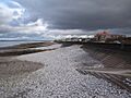
Milefortlet 10 probably lay by the coast between Skinburness and Silloth
 | Charles R. Drew |
 | Benjamin Banneker |
 | Jane C. Wright |
 | Roger Arliner Young |
