Miller Creek (Marin County, California) facts for kids
Quick facts for kids Miller Creek |
|
|---|---|

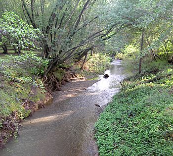
Miller Creek in April 2010.
|
|
|
Location of the mouth within California
|
|
| Country | United States |
| State | California |
| Region | Marin County |
| City | Lucas Valley-Marinwood |
| Physical characteristics | |
| Main source | Big Rock Ridge southwest of Novato 1,670 ft (510 m) 38°3′40″N 122°36′48″W / 38.06111°N 122.61333°W |
| River mouth | San Pablo Bay 0 ft (0 m) 38°1′53″N 122°29′54″W / 38.03139°N 122.49833°W |
Miller Creek is a stream in eastern Marin County, California, United States. It is about 7.6 miles (12.2 km) long. The creek starts on Big Rock Ridge and flows into San Pablo Bay. A local school, Miller Creek Middle School, is named after this important waterway.
Contents
History of Miller Creek
The creek is named after James Miller. He was an Irishman who settled in the area in 1845. He lived on a piece of land that was once part of a large ranch called Rancho San Pedro, Santa Margarita y Las Gallinas.
Miller Creek's Path and Area
The Miller Creek watershed covers about 11.6 square miles (30 km²). A watershed is an area of land where all the water drains into a single stream, river, or lake. Miller Creek begins on Big Rock Ridge, which is southwest of Novato.
The creek flows south towards Lucas Valley Road. Then, it turns east into Gallinas Valley. It runs alongside the road to Miller Creek Road. From there, it crosses Lucas Valley Road and turns north through Marinwood Park. Finally, it turns east again along the southern edge of Marinwood. The creek goes under U.S. Route 101 and flows through channels in McInnes County Park. It then empties into the western part of San Pablo Bay.
Wildlife and Nature in Miller Creek
In recent years, a type of fish called steelhead trout (Oncorhyncus mykiss) has been found in Miller Creek. These fish are a kind of rainbow trout that can live in both fresh and saltwater. Experts from the EPA, Marin County Public Works, and the California Department of Fish and Game believe Miller Creek is a good place to help trout populations grow. This is because the creek has healthy areas along its banks where plants grow, few things block fish from moving, and no large dams or reservoirs.
Creek Health and Pollution
The California Coastal Commission sees Miller Creek as a Critical Coastal Area. This means it's an important coastal area that needs protection. The creek is considered an "impaired water body." This means its water quality is not as good as it should be, and it's listed under a part of the U.S. Clean Water Act. The creek flows next to the San Pablo Bay National Wildlife Refuge, which is a protected area for wildlife.
Since the 1800s, farm animals like cows have grazed in the watershed. This has caused the creek to become wider and deeper in some places. The creek still carries a lot of sediment (like dirt and sand) from this grazing. Also, new neighborhoods built nearby have affected the lower parts of the creek.
Bridges Over Miller Creek
Many bridges cross Miller Creek. These bridges help people and cars travel over the water. For example, there are bridges at Lucas Valley Road, U.S. Route 101, and Mount Shasta Drive. These bridges were built at different times, with some as early as 1925 and others as recently as 1987.
 | Kyle Baker |
 | Joseph Yoakum |
 | Laura Wheeler Waring |
 | Henry Ossawa Tanner |


