Millers, Missouri facts for kids
Quick facts for kids
Millers, Missouri
|
|
|---|---|

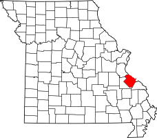
Location of Ste. Genevieve County, Missouri
|
|
| Country | United States |
| State | Missouri |
| County | Sainte Genevieve |
| Township | Union |
| Elevation | 896 ft (273 m) |
| Time zone | UTC-6 (Central (CST)) |
| • Summer (DST) | UTC-5 (CDT) |
| ZIP code |
63670
|
| Area code(s) | 573 |
| FIPS code | 29-48325 |
| GNIS feature ID | 741068 |
Millers is a small place in Missouri, United States. It's not a city or a town with its own government. Instead, it's called an "unincorporated community." This means it's a group of homes and buildings that are part of a larger area, in this case, Union Township. Millers is located in the western part of Sainte Genevieve County. It's about 15 miles southwest of a bigger town called Ste. Genevieve.
What is an Unincorporated Community?
An "unincorporated community" is a place where people live. However, it does not have its own local government. It doesn't have a mayor or a city council. Instead, it is governed by the larger county or township it is part of. For Millers, this means Sainte Genevieve County handles things like roads and public services.
Where is Millers Located?
Millers is found in the state of Missouri. It is in the western part of Sainte Genevieve County. This county is in the eastern part of Missouri. Millers is about 15 miles southwest of the city of Ste. Genevieve. This makes it a quiet, rural spot.
How Millers Started
Millers began as a special spot on the Missouri-Illinois Railroad. It was a "switch spur." A switch spur is a short section of railroad track. It branches off the main line. It allows trains to move from one track to another. This was useful for loading or unloading goods. The switch spur was located between two other communities: Weingarten and Sprott. It was built on land owned by a person named L. R. Miller. This is how the community got its name. The railroad played a big part in its early history.
 | Percy Lavon Julian |
 | Katherine Johnson |
 | George Washington Carver |
 | Annie Easley |

