Mingha River facts for kids
Quick facts for kids Mingha River |
|
|---|---|

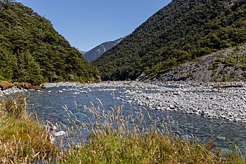
Mingha River close to Mingha Bivouac
|
|
| Country | New Zealand |
| Physical characteristics | |
| Main source | Southern Alps 1,600 m (5,200 ft) |
| River mouth | Bealey River 670 m (2,200 ft) |
| Length | 11 km (6.8 mi) |
The Mingha River is a river found in the Canterbury Region of New Zealand's South Island. It starts high up on the slopes of a mountain called Mt Temple. From there, it flows first towards the east, then turns south. Eventually, it joins another river called the Bealey River, about 8 kilometers (5 miles) south of a famous place called Arthur's Pass.
About the Mingha River
The Mingha River is about 11 kilometers (7 miles) long. It begins way up in the Southern Alps, which are New Zealand's biggest mountain range. The river's source is around 1,600 meters (5,200 feet) above sea level. When it meets the Bealey River, it's at about 670 meters (2,200 feet) elevation.
A Special Route Across the Mountains
The Mingha River valley is part of a special path that crosses the Southern Alps. This path is known as the Mingha/Deception route. It includes the Mingha valley, a place called Goat Pass (which is 1,071 meters or 3,514 feet high), and the Deception River.
The Coast to Coast Race
This Mingha/Deception route is very important for a big annual sports event. It is used for the mountain running part of the famous Coast to Coast race. This race challenges athletes to travel all the way across New Zealand's South Island.
 | Victor J. Glover |
 | Yvonne Cagle |
 | Jeanette Epps |
 | Bernard A. Harris Jr. |

