Moera facts for kids
Quick facts for kids
Moera
|
|
|---|---|
|
Suburb
|
|

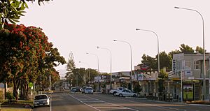
Randwick Road, Moera
|
|
| Country | New Zealand |
| Local authority | Lower Hutt |
| Electoral ward | Harbour |
| Established | 1920s |
| Area | |
| • Land | 63 ha (156 acre) |
| Population
(June 2023)
|
|
| • Total | 1,850 |
Moera is a suburb in the city of Lower Hutt, New Zealand. It is part of the larger urban area of Wellington.
Contents
Where is Moera?
Moera is located at the southeastern end of the Hutt River. The name Moera is thought to come from the Māori phrase "Moe-i-te-ra," which means "sleeping in the sun."
Moera's Past
Before European settlers came, the Moera area was a big, swampy place. This was where the Awamutu and Waiwhetū Streams flowed into the sea. On the southern side of the Waiwhetū Stream, there were several villages of the Ngati Ira people.
In 1843, a man named William Trotter settled here. He started a fruit garden and a plant nursery. In 1855, a big earthquake, called the 1855 Wairarapa earthquake, happened. It lifted the land in the Hutt Valley by 1 to 2 metres. This helped to drain the swampy area.
The land stayed as farmland until 1926. That year, the Petone Railway Workshops moved to Moera. The government also built special houses for the railway workers. These houses were made from pre-cut parts and sold to families.
How Moera Influenced Housing
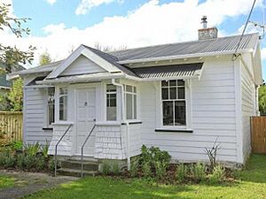
To house the workers, almost 600 "kitset" homes were built. These homes came as a set of parts that could be put together. They had a simple layout with five rooms. The whole project was finished by May 1927. These homes became a model for how State housing would be built in New Zealand later on.
Many of the houses in Moera today are the original pre-cut cottages built by the Railways Department from that time.
What to See in Moera
Moera was once home to the Hutt Park Raceway, starting in the 1860s. This was a place for horse and dog racing. Racing stopped there in 2003. Now, the 12-hectare park is a sports and recreation area. It has a large indoor sports centre with seven courts and an indoor playground for children.
The park is located between the industrial area of Lower Hutt and the homes in Moera. It is bordered by the Waiwhetu Stream, the Gracefield railway line, and Randwick Road.
Close to the park are other useful places. These include businesses between Seaview Road and the Waiwhetu Stream. There is also the Seaview Urupa (a Māori burial ground) and walking paths. These paths connect to the Hutt River and Waiwhetu Stream.
Moera's Population
Moera is about 0.63 square kilometres in size. It had an estimated population of 1,850 as of June 2023, . This means there are about 2937 people per square kilometre.
| Historical population | ||
|---|---|---|
| Year | Pop. | ±% p.a. |
| 2006 | 1,608 | — |
| 2013 | 1,533 | −0.68% |
| 2018 | 1,626 | +1.18% |
In the 2018 New Zealand census, Moera had 1,626 people living there. This was an increase of 93 people since the 2013 census. There were 645 households. The population included 822 males and 807 females. The average age was 36.4 years. About 19.2% of the people were under 15 years old.
People in Moera come from many different backgrounds. In 2018, about 50.0% were European/Pākehā, 26.6% were Māori, 15.7% were Pasifika, and 21.4% were Asian. About 31.0% of the people were born outside New Zealand.
Education in Moera
Randwick School is a primary school in Moera. It is for students from Year 1 to Year 8. It has a roll of 125 students as of February 2024.
 | Frances Mary Albrier |
 | Whitney Young |
 | Muhammad Ali |


