Molitor, Wisconsin facts for kids
Quick facts for kids
Molitor, Wisconsin
|
|
|---|---|

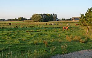
This farm sits in the plain left by an ice-walled lake at the junction of M and E.
|
|

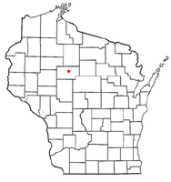
Location of Molitor, Wisconsin
|
|
| Country | |
| State | |
| County | Taylor |
| Area | |
| • Total | 36.0 sq mi (93.1 km2) |
| • Land | 35.3 sq mi (91.4 km2) |
| • Water | 0.7 sq mi (1.7 km2) |
| Elevation | 1,427 ft (435 m) |
| Population
(2010)
|
|
| • Total | 324 |
| • Density | 7.5/sq mi (2.9/km2) |
| Time zone | UTC-6 (Central (CST)) |
| • Summer (DST) | UTC-5 (CDT) |
| Area code(s) | 715 & 534 |
| FIPS code | 55-53550 |
| GNIS feature ID | 1583734 |
| PLSS township | T32N R1W |
Molitor is a small town located in Taylor County, Wisconsin, in the United States. In 2010, the town had a population of 324 people.
Contents
Molitor's Natural Landscape and Features
Molitor covers about 36 square miles (93.1 square kilometers). Most of this area, about 35.3 square miles (91.4 square kilometers), is land. The remaining 0.7 square miles (1.7 square kilometers) is water, like lakes and rivers.
Hills, Lakes, and Glacial History
Much of Molitor is hilly and has many small lakes formed by glaciers. It sits within a special area called the Perkinstown terminal moraine. This moraine was created by the last glacier that covered this region.
When the glacier melted, it left behind unique flat areas with raised edges. These areas were once the bottoms of "ice-walled lakes." These lakes formed when ice blocked the water, creating temporary lakes.
State Natural Areas in Molitor
Molitor is home to three important state natural areas. These places protect special plants, animals, and natural features. They are:
- Lost Lake Esker SNA
- Twin Lakes Bog SNA
- Mondeaux Hardwoods SNA
Molitor's Past: A Look at Its History
The land that became Molitor was first mapped by government surveyors in the mid-1800s. They walked through the forests and over frozen swamps to mark the land.
Early Surveys and Land Description
In 1857 and 1858, surveyors described the area. They noted many swamps with Tamarac and Cedar trees. They said the land was mostly hilly and not the best for farming.
The forests were very thick, with trees like Hemlock, Birch, Pine, and Tamarac. They also mentioned several small lakes and streams, including the East Branch of the Yellow River.
First Settlements and Growth
An 1880 map showed Molitor as mostly undeveloped, with some cranberries growing near the Yellow River. The Town of Molitor was officially formed in 1886.
By 1900, a main road, similar to today's Keyes Avenue, crossed the southern part of the town. Smaller roads branched off, and about fifteen families had built homes. There was a sawmill, a school, and a church. Large parts of the northern area were still unsettled, owned by logging companies like Chippewa Lumber and Boom.
Changes in the Early 1900s
By 1911, more settlers had arrived in the south. Logging companies continued to own much of the northern land. Northwestern Lumber Co. bought land from Chippewa Lumber and Boom.
In 1933, a large part of Molitor became part of the Chequamegon National Forest. This helped protect the natural environment.
Molitor's Community: People and Homes
In 2000, Molitor had 263 people living in 100 households. Most people were White (98.48%). A small number were Native American or from other backgrounds.
Households and Families
Out of 100 households, 31% had children under 18 living with them. Most households (72%) were married couples. About 17% of households were single individuals.
The average household had about 2.63 people, and the average family had about 2.96 people.
Age and Income
The population had a mix of ages:
- 25.1% were under 18 years old.
- 7.2% were between 18 and 24.
- 27.8% were between 25 and 44.
- 28.5% were between 45 and 64.
- 11.4% were 65 years or older.
The average age in Molitor was 40 years. In 2000, the typical household income was $37,500 per year.
See also
 In Spanish: Molitor (Wisconsin) para niños
 | William M. Jackson |
 | Juan E. Gilbert |
 | Neil deGrasse Tyson |

