
Montfode Castle facts for kids
Quick facts for kids Montfode Castle |
|
|---|---|
| Ardrossan, North Ayrshire, Scotland UK |
|

Montfode Castle in the early 19th century
|
|

Montfode Castle
|
|
| Coordinates | 55°39′29″N 4°49′17″W / 55.658166°N 4.821269°W |
| Type | Tower house |
| Site information | |
| Owner | Private |
| Controlled by | Montfode family |
| Open to the public |
No |
| Condition | Ruined |
| Site history | |
| Built | 16th century |
| Materials | Stone |
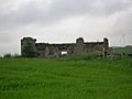
The old Montfode Castle is a ruined building near Ardrossan in North Ayrshire, Scotland. It stands on the Montfode Braes, which are cliffs above an old raised beach. This 16th-century tower house is a protected historical site. You can easily see the castle ruins from the A78 Ardrossan bypass road.
Contents
Exploring Montfode Castle's Past
The name 'Montfode' comes from the Montfode family, who were a Norman family. They were important people in the area for about 500 years. The castle is also very close to the Montfode Burn, which is a small stream.
What's Left of the Castle?

Most of Montfode Castle was taken apart in the early 1800s. Its stones were used to build a dam and other buildings at Montfode Farm. The water from the dam helped power a machine called a threshing mill. Today, the dam and mill building are still there. The area where the water used to collect is now a wet field.
A drawing of the castle was made before its stones were removed. This drawing shows the castle as a large, rectangular building. What remains today is a single round tower, about 8 meters (26 feet) tall. It has narrow openings and a gun-loop, which was a small hole for firing guns. This tower was likely three or four stories high. There is also a piece of wall about 7 meters (23 feet) tall. The main entrance on the east side has a fancy stone frame.
The way the tower is placed suggests the castle might have been a "Z-plan" design. This means it had a main block with towers at opposite corners.
The Threshing Mill at Montfode Farm

As mentioned, stones from the old castle were used to build the dam and threshing mill. A threshing mill is a machine that separates grain (like wheat or barley) from the straw. Before these machines, farmers had to do this by hand.
A Scotsman named Andrew Meikle invented the modern threshing machine in 1786. At the mill, corn was fed into the machine from the first floor. Rollers with brushes separated the grain from the straw. The grain was then collected in bags, and the straw was stored in a barn.
The mill needed a steady supply of water. Water came from the nearby hill and was collected in a pond. There are still signs of the old water control system. The water that had been used by the mill flowed out through a stone tunnel into the Montfode Burn.
Old maps show that small houses for farm workers, called Montfode Cottages, were built nearby in the late 1800s. These workers might have helped run the threshing mill, which probably served other farms in the area.
Old Maps and Montfode Castle
Old maps give us clues about Montfode Castle. A map from 1636-52 shows "Minfod" and the "Minfod Burn." Another map from 1747 shows the castle inside a walled area with trees. By 1775, a map by Armstrong shows "Monfodd" as a ruin.
A map from 1769 shows both Montfode House and the castle. Montfode House was a new home built to replace the old castle. Montfode Wood was also a noticeable feature on this map.
Montfode Mount: An Ancient Mound
This oval-shaped mound is about 500 meters (1,640 feet) south of the castle. It sits near the Montfode Burn, which has caused some erosion. People often thought this mound was an old "motte," which is a type of small hill where early castles were built.
However, some experts believe it was first a burial mound. Later, it might have been used as a fort or a "moot hill," where local meetings or courts were held. Air photos show signs of two circular ditches nearby, and one around the base of the mound. This suggests it's a very old site, possibly from prehistoric times.
The Montfode Estate and Its Stories


Boydston Farm was once called Little Montfode. A local story says that a Montfode laird (landowner) killed a member of the Boyd family. To make up for it, the Montfodes gave this land to the Boyds. The place where the fight happened was known as the 'Cuff Holm'.
Over the centuries, the Montfode family owned various lands in the area. Records show that in 1467, King James III gave many properties, including the 'Lands of Monfode,' to Thomas Earl of Arran. Later, in 1482, the property was officially given to James, Lord Boyd.
In 1691, a "Hearth Tax" record shows that the House of Montfode had four hearths (fireplaces), which meant it was a fairly large home. Several other people living on the estate had one hearth each.
Montfode and a Famous Trial

Montfode was connected to a famous event in 1769. This was the trial of Mungo Campbell, who was involved in the death of the 10th Earl of Eglinton.
On the day the Earl died, Mungo Campbell was walking through the Montfode lands. He then crossed a stream that marked the border between Montfode and the Earl of Eglinton's property. They were hunting woodcock in the Montfode Burn valley.
Mungo Campbell had permission to hunt on Montfode lands. However, after crossing into the Earl's land, the Earl accused him of poaching (hunting illegally). This led to an argument, and the Earl was shot and died. The old "kirk-road" (church road) that Mungo Campbell walked on is clearly shown on the 1769 map.
Families Connected to Montfode
The Montfode Landowners

The Montfode family was a Norman family with many different spellings for their name. They were important in the area for about 500 years.
In 1511, a man named John Montfode, along with the Earl of Eglinton, got into trouble. They went to a man's house, hurt his wife, and took him to jail for six hours.
Later, in 1547, James Montfode was killed in a battle called the Battle of Pinkie. In 1568, another John Montfode was one of several landowners who protested to the Scottish Parliament. They were upset about losing their lands because the Earl of Eglinton had supported Mary Queen of Scots.
The Montfode family line ended in the 1600s. Only one line, through Janet Montfode who married Archibald Steel, can still claim a connection to the original Montfodes.
Family Symbol (Coat of Arms)

It is thought that the Montfode family used the same coat of arms as the Montfort family. This symbol showed a red shield with a silver lion standing on its hind legs, with a forked tail. In the old Ardrossan burial ground, near the castle ruins, there is a tombstone. Local stories say it belongs to the Montfode family. It has a carving of an "armed man" and a shield with a faded image of a lion.
Other Families: Craufurd, Miller, Montgomerie, Brisbane, Ramsay, Hunter, Carrick, Moore
Over the years, Montfode Castle and its lands were owned by several different families.
In 1661, the Earl of Eglinton briefly owned Montfode. Then, in 1682, it passed to William Brisbane, who was a doctor and surgeon. He was also a leader in the Presbyterian church.
Later, in 1714, Dr. William Ramsay bought the lands. By 1769, a Dr. Hunter owned them.
Finally, a Glasgow banker named Robert Carrick bought the lands. In 1821, James Moore took over and changed his name to Carrick. James Carrick Moore was the brother of General Sir John Moore, a famous British Army officer.
The Kilbirnie Seer's Prophecy
There's a story about the last of the Montfode family. Sir Hugh Montfode adopted his niece, Emma Crawfurd, as his only heir. Emma fell in love with Richard Hunter, who returned from abroad wealthy. However, he lost all his money in a shipwreck near Scotland.
Sir Hugh Montfode didn't want Emma to marry Richard at first. But after Richard saved Emma from kidnappers, Sir Hugh changed his mind, and they got married. Sadly, Emma died young and without children. Her grave is said to be an old grey stone in Ardrossan churchyard, dated 1661.
Here is the Montfode prophecy: When a fatherless child, and a childless father, Shall live in love and sorrow together; When the houlet shall big in the auld tower wa', And the oak its green leaves shed in the ha';
When a rose tree shall blossom on Emmeline's Walk, With only one lonely flower on its stalk; When a hameless wanderer shall come frae abroad, And thowless trust in the house of Montfode;
When the water is dry in St. Winning's well, And there is not a monk the cause to tell; When a sparrow shall chase frae its eyrie the hawk, And the cock, at gloamin', craw thrice on the bauk;
When the locusts shall eat up the corn in the ear, The end of the house of Montfode is near.
Views of Montfode Farm and Threshing Mill
-
Ruins of the Montfode Cottages.
-
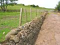
Old dam wall built from the old castle stones.
-
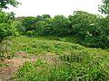
Cuff Holm - where a Boyd was killed by a Montfode.
-
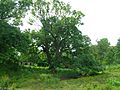
Ancient Sycamore tree and Montfode Cottages.
-
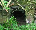
Stone-lined tunnel for water leaving Montfode House.
-
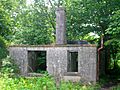
Townhead of Montfode, farm ruins.


Smuggling History
The area around the Montfode Burn was known as a place where smugglers often hid their illegal goods. A marshy area near Newhouse (now Burnhouse) was also a popular hiding spot for smuggled items.
Interesting Facts About Montfode

- William Montfode was in charge of the children of Alexander of Cuninghame in 1660.
- John Montfode, the last of his family line, was part of a group that looked into the state of the Scottish church in 1662.
- There's a local legend that Montfode Castle is connected to Ardrossan Castle by a secret underground tunnel.
- A "Chapelhill" is located just east of Montfode Castle.
- A "horse gin," which was a machine powered by horses, was once in a circular building attached to Montfode Farm.
- The entrance lane to the old raised beach has unusual trees in its hedgerow. These are hybrids of common whitebeam and wild service tree.
