Moorefield, Kentucky facts for kids
Quick facts for kids
Moorefield
|
|
|---|---|
 |
|
| Country | United States |
| State | Kentucky |
| County | Nicholas |
| Elevation | 988 ft (301 m) |
| Population
(2010)
|
|
| • Total | 228 |
| Time zone | UTC-5 (Eastern (EST)) |
| • Summer (DST) | UTC-4 (EDT) |
| ZIP codes |
40350
|
| GNIS feature ID | 498562 |
Moorefield is a small, quiet community in Nicholas County, Kentucky, United States. It's known as an "unincorporated community." This means it doesn't have its own local government like a city or town. Instead, it's part of the larger county.
Contents
Exploring Moorefield: Location and Features
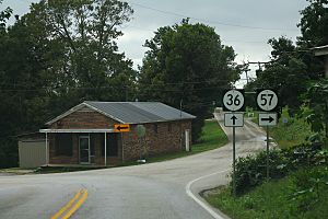
Moorefield is located in the southeastern part of Nicholas County. It sits along two important roads: Route 36 and Route 57. These roads connect Moorefield to other places.
Where is Moorefield Located?
Moorefield is southeast of Carlisle. Carlisle is the main town in Nicholas County, also known as the county seat. The community of Moorefield is about 988 feet (301 meters) above sea level.
What is Moorefield's ZIP Code?
Even though it's a small community, Moorefield has its own post office. The ZIP code for Moorefield is 40350. This helps mail get to the right place.
Notable People from Moorefield
Some interesting people have connections to Moorefield. One person who lived here was Robert M. Talbert.
Who was Robert M. Talbert?
Robert M. Talbert was a politician from Missouri. A politician is someone who works in government. He was also a chaplain. A chaplain is a person who provides religious services, often for groups like the military or a legislature.
 | Mary Eliza Mahoney |
 | Susie King Taylor |
 | Ida Gray |
 | Eliza Ann Grier |


