Mosher, Missouri facts for kids
Quick facts for kids
Mosher, Missouri
|
|
|---|---|

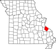
Location of Ste. Genevieve County, Missouri
|
|
| Country | United States |
| State | Missouri |
| County | Sainte Genevieve |
| Township | Sainte Genevieve |
| Elevation | 443 ft (135 m) |
| Time zone | UTC-6 (Central (CST)) |
| • Summer (DST) | UTC-5 (CDT) |
| ZIP code |
63670
|
| Area code(s) | 573 |
| FIPS code | 29-50258 |
| GNIS feature ID | 721737 |
Mosher is a small place in Missouri, United States. It is known as an "unincorporated community." This means it does not have its own local government like a city or town. Instead, it is part of a larger area called Ste. Genevieve Township. Mosher is located in eastern Sainte Genevieve County. It is about two miles west of the city of Ste. Genevieve.
What is Mosher?
Mosher is an unincorporated community. This means it is a group of homes and businesses that are not officially part of a city or town. People living in Mosher get their services from the county or township. This is different from a city, which has its own mayor and city council.
Where is Mosher Located?
Mosher is found in the eastern part of Sainte Genevieve County. This county is in the state of Missouri. It is quite close to the city of Ste. Genevieve. You can find Mosher just two miles west of that city.
The Story Behind the Name
The name "Mosher" likely came from a local family. This family was French colonial, meaning they were early French settlers. Their name was probably Mosier or Mosieur. Over time, the English spelling of the name changed. This is how "Mosher" became the name of the community.
How Mosher Grew
Mosher became a community because of the Missouri-Illinois Railroad. It developed as a stop along this important railway line. Railroad stops were often places where people could get on or off trains. They were also used for loading and unloading goods. This helped the community of Mosher to grow.
 | Kyle Baker |
 | Joseph Yoakum |
 | Laura Wheeler Waring |
 | Henry Ossawa Tanner |

