Motiti Island facts for kids

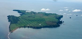
An aerial view of Motiti Island.
|
|
| Geography | |
|---|---|
| Location | Bay of Plenty |
| Coordinates | 37°37′33″S 176°25′20″E / 37.6257°S 176.4221°E |
| Total islands | 1 |
| Major islands | 1 |
| Area | 10 km2 (3.9 sq mi) |
| Highest elevation | 57 m (187 ft) |
| Administration | |
| Demographics | |
| Population | 27 (2006) |
| Pop. density | 2.7 /km2 (7 /sq mi) |
| Ethnic groups | Maori |
Motiti Island (which is called Mōtītī in the Māori language) is a small island located off the coast of New Zealand's North Island. It is found in the Bay of Plenty area. The island is about 21 kilometers (13 miles) north-east of Tauranga city. It is also 9.4 kilometers (5.8 miles) north-east of Papamoa. In 2006, there were 27 people living in 18 homes on the island.
Contents
About Motiti Island
Motiti Island is a fairly flat island. It covers an area of about 10 square kilometers (3.9 square miles). The island is mostly made of old volcanic rocks. Newer layers of soil cover these rocks in the southern part of the island.
Most people on the island work in farming. There is a growing farm that produces avocados. Most residents and visitors travel to the island by plane. This is because there are no public docks or roads. The entire island is privately owned. This means getting to the island can be difficult and costly.
The Bay of Plenty Regional Council is in charge of some things on Motiti Island. However, no local city council is responsible for it. This means people living there do not pay local taxes. Also, there are no city council services like public waste collection. The Department of Internal Affairs handles the island's daily management.
History and Culture
Early History
On November 2, 1769, the famous explorer Captain Cook sailed close to Motiti Island. He was on his first voyage. Captain Cook wrote in his journal that he saw many fortified villages on the island. These were the most he had seen so far. He called the island "Flat Island" in his writings.
Recent Events
In 2011, a large cargo ship called the MV Rena crashed into Astrolabe Reef. This reef is near Motiti Island. Oil from the crash, known as the 2011 Tauranga oil spill, spread to the island's shores. Shipping containers and their contents also washed up on the island.
In October 2013, the owners of the MV Rena offered a deal to the people of Motiti Island. They wanted to leave the ship's wreckage on the reef. In return, they offered to help develop the island. The plan included several improvements:
- Building a place for barges to land.
- Creating a new road to the airstrip. This road would be usable in all weather.
- Installing a new cell phone tower for better communication.
- Running an underground cable from the mainland for better power.
- Placing a permanent light on Astrolabe Reef.
- Building a memorial from the ship's anchor.
However, the residents of Motiti Island decided to reject this offer.
Marae on the Island
Motiti Island has two special meeting places called marae. These marae belong to the Ngāti Awa sub-tribes (hapū) of Ngāti Maumoana, Ngāti Makerewai, and Ngāti Takahanga.
- Te Hinga o te Ra Marae, which also has a meeting house called Te Hinga o te Ra.
- Te Rua Kopiha Marae, which has a meeting house called Tamatea ki te Huatahi.
In 2020, the New Zealand Government provided money to upgrade several marae. Te Rua Kopiha Marae on Motiti Island was one of them. This funding helped create jobs and improve the marae.
Getting to Motiti Island
Sunair is an airline that flies to Motiti Island. They use small Cessna 172 planes. These flights connect Motiti Island with Tauranga.
See also
 In Spanish: Isla Motiti para niños
 | Janet Taylor Pickett |
 | Synthia Saint James |
 | Howardena Pindell |
 | Faith Ringgold |


