Motukawao Islands facts for kids
|
Māori: Motukawao
|
|
|---|---|

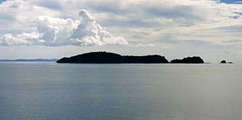
Motukawao Islands and Hauraki Gulf from Amodeo Bay, near Colville.
|
|
| Geography | |
| Location | Waikato region |
| Coordinates | 36°41′24″S 175°24′00″E / 36.690°S 175.400°E |
| Administration | |
| Demographics | |
| Population | 0 |
The Motukawao Islands are a group of small islands in New Zealand. They are located in the Hauraki Gulf, which is off the west coast of the Coromandel Peninsula. These islands are the most northern ones in this area. They are about 5 kilometers (3 miles) southwest of a town called Colville. No one lives on these islands.
About the Motukawao Islands
The Motukawao Islands are a beautiful part of New Zealand's natural landscape. They are a cluster of small landmasses rising from the sea. These islands are important for their wild and untouched nature.
The biggest islands in the group are Motuwi and Ngamotukaraka Islands. Other islands include Moturua and Motukaramarama Islands. Even though they are close to the mainland, these islands are completely uninhabited, meaning no people live there. This helps keep them wild and natural.
Island Life: Birds and Nature
One special island in the group is Motukaramarama Island. It's about 3.5 kilometers (2 miles) from the coast. This island is very important for birds.
BirdLife International, an organization that works to protect birds, has named Motukaramarama Island an Important Bird Area. This is because it is a nesting site for many birds. About 3,500 pairs of Australasian gannets make their homes and raise their young here. Gannets are large seabirds known for their amazing diving skills when they hunt for fish.
 | William M. Jackson |
 | Juan E. Gilbert |
 | Neil deGrasse Tyson |

