Mount Dale facts for kids
Quick facts for kids Mount Dale |
|
|---|---|

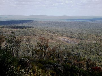
View southeast from the summit of Mount Dale
|
|
| Highest point | |
| Elevation | 546 m (1,791 ft) |
| Geography | |
| Location | East of Karragullen, Western Australia |
| Parent range | Darling Scarp |
Mount Dale is a mountain located in Western Australia. It stands about 25 kilometers (15.5 miles) east of Armadale. This mountain is part of the Shire of Beverley.
At 546 meters (1,791 feet) high, Mount Dale is one of the tallest spots in the Darling Scarp. It is a popular place for hiking and enjoying nature.
Contents
Exploring Mount Dale
Mount Dale is well-known for its walking path. This path is part of the famous Bibbulmun Track. The Bibbulmun Track is a long walking trail in Western Australia.
The Walk to the Summit
The trail to the top of Mount Dale starts from a parking and picnic area. It goes through about 500 meters (1,640 feet) of beautiful jarrah forest. In spring, this forest comes alive with many colorful wildflowers.
From some areas, like Glen Forrest, you can even see Mount Dale. It is visible when looking south-southeast from outside Helena College on Bilgoman Road.
Mount Dale's History
Mount Dale was once an important place for spotting fires. It had a fire lookout tower because it offered amazing 360-degree views. These views covered the National Park and nearby State Forest areas.
From Lookout to Communications
Today, a communications tower has replaced the old fire lookout tower. This new tower blocks some of the wide views. However, you can still see parts of the old tower's base hidden in the plants. You can also find stunning panoramic views from the parking area just below the peak.
The mountain was named after Robert Dale. He was an explorer who, in 1829, became the first European to explore the Darling Scarp.
 | Emma Amos |
 | Edward Mitchell Bannister |
 | Larry D. Alexander |
 | Ernie Barnes |

