
Mount Douglas, Saanich facts for kids
Quick facts for kids Mount Douglas |
|
|---|---|
 |
|
| Highest point | |
| Elevation | 225 m (738 ft) |
| Prominence | 225 m (738 ft) |
| Geography | |

Mount Douglas
Location in British Columbia
|
|
Mount Douglas (also known as PKOLS in the SENĆOŦEN language) is a tall hill in Saanich, British Columbia, Canada. It stands about 225 meters (738 feet) high. This special hill is found within Mount Douglas Park. It is on the traditional lands of the Saanich and Songhees Indigenous peoples.
Contents
What's in a Name?
The original people of this land, the Saanich and Songhees, called this hill PKOLS (pronounced pq̕áls). This name means "White Head" in their SENĆOŦEN language. PKOLS was a very important place for these Indigenous groups. They used it for gatherings, ceremonies, and sharing important news.
How Did Mount Douglas Get Its Name?
In the mid-1800s, the hill was first called Cedar Hill. People used to cut down trees here to supply wood for the growing city of Victoria. However, a captain named Henry Kellett noticed there were no cedar trees on the hill. So, he decided to rename it "Mount Douglas" to honor the governor at the time, James Douglas. This new name became official in 1910.
Reclaiming the Original Name
In 2013, a movement began to bring back the original Indigenous name, PKOLS. This group, called the "Reclaim PKOLS movement," wants the BC Geographical Names Office to officially change the name. The request is still being reviewed.

The Area Around the Mountain
The neighborhood around Mount Douglas is a mix of homes and farms. It includes working farms and smaller "hobby farms." These farms are protected by a special provincial program called the Agricultural Land Reserve. This helps make sure the land stays used for farming.
Exploring the Mount Douglas Mine
Mount Douglas has many trails for people to explore. On the south side of the hill, there is an old, unused mine. The entrance to the mine is small, but it opens up inside. The mine tunnel is about 15 to 18 meters (50 to 60 feet) long.

Mount Douglas Park
Mount Douglas–PKOLS is located inside Mount Douglas Park. This park is quite large, covering 188 hectares (about 465 acres). It was first protected in 1858 and then officially made a park in 1889. The city of Victoria looked after the park until 1990. After that, the District of Saanich took over its management.
Images for kids
-
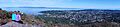
Looking southeast from Mount Douglas.
-
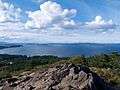
View from the top of Mount Douglas looking north.
-
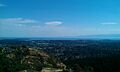
View from the top of Mount Douglas looking south.
-
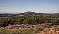
View from Christmas Hill looking towards Mount Douglas.


