Mount Howell facts for kids
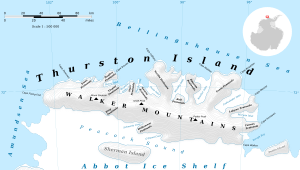
Mount Howell is a mountain located in Antarctica, a very cold continent at the South Pole. It stands about 5.5 kilometers (3 nautical miles) southwest of Mount Borgeson. This mountain is part of the Walker Mountains, which are found on Thurston Island.
Contents
About Mount Howell
Mount Howell is a significant landmark on Thurston Island. Its exact location is at 72°14′S 99°3′W / 72.233°S 99.050°W. This mountain is part of the rugged landscape of Antarctica, a continent known for its icy mountains and vast, frozen plains.
How Mount Howell Got Its Name
Mount Howell was named by a group called the Advisory Committee on Antarctic Names. This committee is responsible for naming places in Antarctica. They named the mountain after Lieutenant Commander John D. Howell. He was a pilot and airplane commander in the U.S. Navy.
John D. Howell and Operation Highjump
John D. Howell was part of a large U.S. Navy expedition called Operation Highjump. This expedition took place in 1946 and 1947. Its main goal was to explore and map parts of Antarctica using airplanes. During this mission, Commander Howell and his team took many aerial photographs of Mount Howell and the nearby coastal areas around Thurston Island. These photos helped scientists and explorers learn more about this remote part of the world.
A Daring Rescue Mission
Commander Howell is also remembered for a brave rescue mission. On January 11, 1947, he landed his PBM Mariner seaplane in the open water of eastern Glacier Bight. His mission was to rescue six people who had survived a plane crash. Their Mariner seaplane had crashed on Noville Peninsula a few weeks earlier, on December 30. This rescue showed the courage and skill of the pilots involved in exploring Antarctica.
Maps
 | DeHart Hubbard |
 | Wilma Rudolph |
 | Jesse Owens |
 | Jackie Joyner-Kersee |
 | Major Taylor |


