Mount King William facts for kids
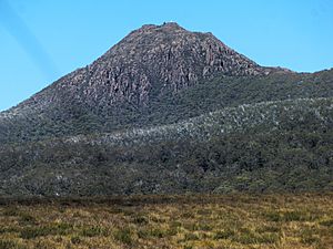
Mount King William I is a tall mountain in Tasmania, Australia. It stands 1,324 meters (about 4,344 feet) high. This mountain is right next to the Lyell Highway in the Central Highlands area. It is about 10 kilometers (6 miles) southwest of a town called Derwent Bridge. Mount King William I is the most northern mountain in a group known as the King William Range.
About the King William Mountains
Mount King William I is part of a mountain range that includes two other mountains with similar names. These are Mount King William II, which is even taller at 1,363 meters, and Mount King William III. These mountains are all named after kings, even though the area was explored when a queen was on the throne!
Location and Surroundings
Mount King William I is often seen as a landmark for travelers on the western part of the Lyell Highway. After this point, there are no towns or permanent buildings until you reach Linda. The mountain is also located within the eastern edge of the Franklin-Gordon Wild Rivers National Park. This park is famous for its wild rivers and beautiful nature.
There is also a large body of water nearby called Lake King William. This lake is south of Derwent Bridge. It has a dam at its southern end, near a place called Butlers Gorge. This dam helps to create electricity.
How the Mountain Got Its Name
Mount King William was named during a trip by Sir John Franklin in 1842. Sir John Franklin was an explorer and governor. Even though the mountain was named after a King William, the ruler of England at that time was actually Queen Victoria.
Later, in the 1880s, a famous artist named WC Piguenit painted Mount King William I. He was on a journey through the area, capturing its natural beauty in his artwork.
 | Roy Wilkins |
 | John Lewis |
 | Linda Carol Brown |


