
Mount Taylor (Australian Capital Territory) facts for kids
Quick facts for kids Mount Taylor |
|
|---|---|

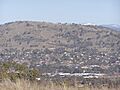
Mount Taylor viewed from Red Hill.
|
|
| Highest point | |
| Elevation | 856 m (2,808 ft) |
| Geography | |

Mount Taylor
Location in Australian Capital Territory
|
|
| Location | Australian Capital Territory, Australia |
Mount Taylor is a well-known hill in Canberra, Australia. It stands tall at 856 meters (about 2,800 feet) above sea level. This important landmark sits between the Woden Valley, Weston Creek, and Tuggeranong Valley areas.
Mount Taylor is part of the Canberra Nature Park. It is surrounded by suburbs like Kambah, Fisher, Waramanga, Chifley, Pearce, and Torrens. Many people enjoy walking and hiking on its trails. While you can't drive to the very top, there's a special fire trail that makes it easy to walk up. This trail is great for families and older walkers. It was even partly paved in 2009 to make it safer for everyone.
Contents
Exploring Mount Taylor's Trails
Mount Taylor has several popular paths for walking and hiking. Each path offers a different experience for visitors. You can choose a trail that fits how much exercise you want!
Easy Walks: The Fire Trail
From the Chifley side, you can find the fire trail. This trail is also called the management trail. It starts near Waldock Street, where there's a car park and picnic tables. The fire trail is usually closed to cars, but it has special openings for walkers. It's known for being the easiest and most relaxing way to reach the top.
Challenging Hikes: The Foot Trails
From the Tuggeranong (Kambah) side, there's a popular foot trail. You can get to it from a car park off Sulwood Drive. This path is well-built with concrete and compacted gravel. It's longer and steeper than the fire trail. This makes it a favorite for people who like to run or get a good workout. Dog owners also use it to exercise their pets.
Another track, called the zig-zag track, is on the north side. It was built in 2007. This path has signs with old photos and facts about local wildlife. Near the top, it goes over some rocky steps. This zig-zag track replaced a much steeper, harder path that used to be there. The new track is safer and easier to walk.
There's also a very steep track on the eastern side. It goes almost straight up from Hawker Street in Torrens. This path is rougher and less formed. It's a big challenge for many walkers. About halfway up, you can see an area called The Sandpit. This is a large erosion gully that formed after heavy rains a long time ago.
What You'll Find at the Top
When you reach the summit of Mount Taylor, you'll see a few things. There's a trig point, which is a marker used for surveying land. You'll also find a National Transmission Station. This station helps send television and FM radio signals to nearby valleys. Plus, there are two benches where you can rest. Two panoramic maps show you the amazing views of Woden and Tuggeranong valleys.
Mount Taylor's Past: A Naming Story
Mount Taylor was named after James Taylor. He was an early settler in the area before 1829. An old map from that time shows Taylor's huts close to where the Yarralumla homestead is now. James Taylor was related to Colonel George Johnston. Colonel Johnston was a leader in the New South Wales Corps. This group was involved in the "Rum Rebellion" in 1808, which was a big event in early Australian history. Mount Taylor was first called Taylor's Hill. It was renamed Mount Taylor when Canberra was being developed.
Wildlife and Nature on Mount Taylor
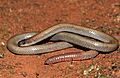
_(9105308465).jpg)
Mount Taylor is a very important natural area. It's listed on the Register of the National Estate because it's such a key landmark in southern Canberra. It's also home to some special and rare animals and plants.
Animals and Plants You Might See
One of the most important animals living here is the Pink-tailed worm-lizard. This lizard is nationally endangered, which means it's at risk of disappearing forever. Mount Taylor has one of the largest known groups of these lizards. You might also find a nationally endangered plant called the Small Purple-pea.
The area also has two nationally endangered plant communities. These are groups of plants that grow together. One is a woodland with Yellow Box and Blakely's Red Gum trees. The other is a lowland temperate grassland. Mount Taylor also shows how different types of forests and woodlands blend together.
Caring for Mount Taylor's Environment
A group called the Mount Taylor park care group started in 1989. They help keep the park healthy by removing unwanted plants (weeds). They also watch the bird population. Over 85 different kinds of birds have been seen on the hill and nearby. This shows how rich in wildlife Mount Taylor is!
Mount Taylor's Rocks and Shape
Mount Taylor has a long shape that points towards the north-northwest. This direction is similar to the nearby Murumbidgee River. A ridge, which is like a long hill, goes north from Mount Taylor to Oakey Hill. This ridge separates the Woden Valley from Weston Creek. Another ridge curves around to the east, forming Farrer Ridge.
How Mount Taylor Was Formed
The rocks on Mount Taylor are very old, about 420 million years old. They are volcanic rocks, meaning they came from volcanoes. On the top and western sides, there's a rock called ignimbrite. This rock formed from huge volcanic explosions. Hot volcanic particles shot into the air and then fell to the ground, hardening into this rock. This type of rock is part of something called the Laidlaw Volcanics.
On the northern and lower eastern slopes, you'll find a rock called rhyodacite. This rock is from the Deakin Volcanics. There's also a type of rock called porphyry that pushed its way into the volcanic rocks on the east and south slopes. The way the rock layers are tilted helps explain the mountain's long shape.
Human Impact and Features Around Mount Taylor
People have built things around Mount Taylor over the years. The Tuggeranong Parkway road forms one edge of the nature park. Sulwood Drive makes up the southwest and southern border. On the eastern side, some houses have backyards that touch the park. Waldock Street gives access to the northern part of the mountain.
Infrastructure and Past Uses
Large power lines run around the west and south of the hill. These lines connect different power stations. There's also a horse riding trail along the back of Woden Valley. This trail connects to a special area for horses on the southeast ridge of Mount Taylor. You can also find several water supply reservoirs on the hill behind the suburbs.
After a big flood in 1971, a special floodway was built at the base of the mountain. This was to protect homes in Pearce and Torrens from future floods. In the past, during the 1960s and 1970s, sheep used to graze on parts of the mountain. This stopped when the mountain reserve became part of the Canberra Nature Park.
Images for kids
-
Mount Taylor viewed from Red Hill.
-
The vulnerable Pink-tailed Worm-lizard occurs on Mount Taylor
