
Red Hill, Australian Capital Territory facts for kids
Quick facts for kids Red HillCanberra, Australian Capital Territory |
|||||||||||||||
|---|---|---|---|---|---|---|---|---|---|---|---|---|---|---|---|

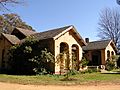
Red Hill shops
|
|||||||||||||||

Red Hill
Location in Australian Capital Territory
|
|||||||||||||||
| Population | 3,170 (2016 census) | ||||||||||||||
| • Density | 650.9/km2 (1,686/sq mi) | ||||||||||||||
| Established | 1928 | ||||||||||||||
| Gazetted | 20 September 1928 | ||||||||||||||
| Postcode(s) | 2603 | ||||||||||||||
| Area | 4.87 km2 (1.9 sq mi) | ||||||||||||||
| District | South Canberra | ||||||||||||||
| Territory electorate(s) | Kurrajong | ||||||||||||||
| Federal Division(s) | Canberra | ||||||||||||||
|
|||||||||||||||
Red Hill is a suburb in Canberra, Australian Capital Territory, Australia. Its postcode is 2603. The suburb gets its name from a hill to its west. This hill is part of a nature reserve called Canberra Nature Park. The hill is also an important part of the original design for central Canberra.
Contents
A Look Back: Red Hill's History
The name 'Red Hill' became official for the suburb in 1928. People had called the hill by this name since the first settlers arrived. It was likely named for the red soil found in the area. Many streets in Red Hill are named after famous ships and explorers. Mugga Way is named after an Aboriginal word that was also used for this area long ago.
Early Days and Land Use
The Red Hill area was once part of a large land lease held by Charles Russell. He used the land to graze sheep. However, as more houses were built, local pet dogs sometimes bothered and killed his sheep. So, he switched to raising cattle. Eventually, he gave up the lease in 1992.
Old Red Hill: A Special Area
The area known as the Red Hill Precinct, or "Old Red Hill," is a special part of the suburb. It is bordered by Mugga Way, Moresby Street, Arthur Circle, Monaro Crescent, and Flinders Way. The main streets in this area were planned by Walter Burley Griffin in 1918. He was the architect who designed Canberra. This area shows off the "garden city planning" style from the 1920s. This means it was designed to have lots of green spaces and a natural feel. The ACT Heritage Council has listed it as a place of historical importance.
Growing Up: Houses and Homes
The first land in Red Hill for building houses was sold on December 12, 1924. By 1929, 22 houses had been built. By 1955, there were 64 houses.
Places with Heritage Value
Several other places in Red Hill are also listed by the ACT Heritage Council because of their historical or architectural importance:
- Calthorpes' House: A historic home that shows what life was like in early Canberra.
- Royal Australian Institute of Architects Headquarters: This building at 2a Mugga Way was designed in 1967 by Bryce Mortlock.
- Canberra Grammar School: This school was built between 1929 and 1939. Its style is called Inter-war Gothic.
- 145 Mugga Way: This house is a great example of the "late twentieth century Sydney Regional style" of architecture. It was designed by Allen Jack+Cottier.
- Red Hill Camp: This was a campsite used by the Ngunnawal people in the 1940s. It is located where Flinders Way, Durville Crescent, and Hayes Crescent meet.
What Can You Do in Red Hill?

Red Hill: A Nature Escape
The most important place for fun and relaxation in Red Hill is the hill itself. It's part of the Canberra Nature Park. People love to walk on its slopes and enjoy the bushland. One resident wrote in a newspaper in 2000:
- "Most Sundays I walk on the slopes of Red Hill in bush that is not pristine, not especially beautiful, but that is there close to where I live, a bit of bush rather than town earth and rock, not bitumen. There is a variety of birds, a miscellany of trees, some of them exotics, a range of weedy but pretty flowers, no doubt snakes, and certainly kangaroos. Ironically, a month ago I saw more kangaroos (a mob of 14) on Red Hill in the centre of Canberra than I saw subsequently during the entirety of a 16-day tour of the Red Centre. This Red Hill bush it can't be called wilderness makes Canberra a better place to live for the many people who do walk there and enjoy its qualities."

Schools in Red Hill
Red Hill has several schools:
- A local public primary school and a government preschool are in the same building. Red Hill School is an IB World School.
- St Bede's Primary School, which is a Catholic primary school.
- Canberra Grammar School, an Anglican school for both boys and girls.
- A French-Australian preschool.

Students living in Red Hill usually get preference for:
- Red Hill Primary or Forrest Primary (depending on their address).
- Telopea Park School for high school.
- Narrabundah College for college.
Special Places to Visit
Calthorpes' House: A Step Back in Time
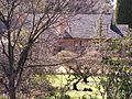
Calthorpes' House at 24 Mugga Way was built in 1927. It was designed for Harry Calthorpe and his family. The house shows many features of the Spanish Mission style. The family lived there through tough times like the Depression and World War II. After Harry's death, his wife continued to live there. She never redecorated, unlike her friends and neighbors.
After she passed away in 1979, people realized the house was a perfect snapshot of early Canberra life. The Australian government bought the house, its garden, and everything inside in 1984.
The Australian Institute of Architects says the house is a rare example of a 1920s Australian home that hasn't changed much. It shows what family life was like back then. The kitchen and bathroom designs were very modern for their time.
-
House from front garden
-
Back garden, including orchard
-
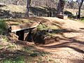
World War II air raid shelter in back garden
-
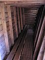
Air raid shelter interior


Boxford Garden
Boxford was a special garden designed by Polly Park. It had six different sections, each showing garden styles from around the world. One part was a Japanese garden. Another had a fountain inspired by a chapel and ideas from a Brazilian garden designer. This garden was listed on the ACT Heritage Register and was even shown on the TV show Burke's Backyard.
-
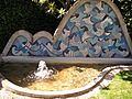
Fountain
-
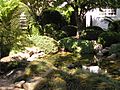
The Japanese garden


Sadly, new owners later destroyed this special garden, even though it was heritage-listed.
Getting Around: Major Roads
To get to Red Hill from the south, you can take Hindmarsh Drive and then turn onto Mugga Way or Dalrymple Street. The main roads that go through the suburb are La Perouse Street, Flinders Way, and Monaro Crescent. Just like some of the smaller streets, these main roads are also named after ships and explorers.
Who Lives in Red Hill? Demographics
The first families moved to Red Hill in 1927. By 1933, 132 people lived there. The population was highest in 1971, with 4,100 residents.
In the 2016 census, Red Hill had 3,170 people. This was a small decrease from 3,249 people in 2011. However, it was a slight increase from 3,143 people in 2006 and 3,062 in 2001. The number of people living in Red Hill hasn't changed much in the last ten years.
The average age of people in Red Hill in 2016 was 41 years old. This is a bit older than the average age in Canberra. The average household size was 2.7 people.
In 2016, most homes in Red Hill were separate houses (73.1%). About 11.4% were townhouses or semi-detached homes, and 14.9% were flats or apartments. Most homes (65.2%) were owned by the people living in them or were being bought. About 30.5% of homes were rented.
Politics in Red Hill
|
|||||||||||||||||||||||||||||||||
Red Hill is part of the federal electorate called Canberra. This means people in Red Hill vote for a representative in the House of Representatives. Currently, Alicia Payne represents this area.
In the ACT Legislative Assembly, Red Hill is in the electorate of Kurrajong. This area elects five members. Currently, two are from the Labor party, two are from the Liberal party, and one is from the Greens. The table on the right shows how people voted at the Red Hill School polling place in recent elections.
Red Hill's Landscape and Rocks

The Red Hill ridge forms the south-west edge of the suburb. This ridge acts like a natural wall, separating the central Canberra valley from the Woden Valley. The northernmost point of this ridge is Red Hill itself. The Davidson Trig is in the middle, and Mount Mugga is at the southernmost end, across Hindmarsh Drive.
The suburb covers an area of 4.87 square kilometers. It has about 634 people living in each square kilometer.
How Red Hill's Rocks Were Formed
Geologists say that the Red Hill ridge was formed by metamorphosis of sedimentary rock. This means that the original soft sediments were changed into harder rock by heat and pressure. The rocks from the Yarralumla Formation became very tough because of heat from a small granite rock deep underground. This tough rock forms the strong core of the ridge.
The granite itself is deeply weathered and doesn't show on the surface. But you can see its effect in the smooth slopes and deep red soils on the lower north-west side, near the road to the Federal Golf Course. This granite is called Federal Golf Course Tonalite. It is about 417 million years old. It is made of crystals and contains minerals like plagioclase, hornblende, biotite, and quartz.
The red soil found here is known as terra rossa.
-
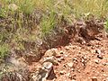
Recently exposed soil. Red Hill gained the name from the colour of its soil.
-
This rock is from a still-standing metamorphic ridge
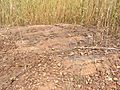
-
Small disused quarry on west side of the ridge
-
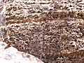
Exposed rock in disused small quarry, showing interesting weathering features


Where to Find Different Rocks
Most of the built-up area of Red Hill has dark grey to green grey dacitic tuff from the Mount Painter Volcanics. The Yarralumla Formation rocks can be seen on Red Hill down to Mugga Way. The Federal Golf Course, which is on the west side of Red Hill, is also part of the suburb. Underneath the entire golf course is a Silurian tonalite rock, which is a type of granite.
