Myers Glacier facts for kids
Quick facts for kids Myers Glacier |
|
|---|---|

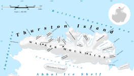
Map of Thurston Island
|
|
| Location | Ellsworth Land |
| Coordinates | 72°16′00″S 100°07′00″W / 72.26667°S 100.11667°W |
| Length | 7 nautical miles (13 km; 8.1 mi) |
| Thickness | unknown |
| Terminus | Peacock Sound |
| Status | unknown |
The Myers Glacier is a long river of ice found in a very cold part of the world. It is located on Thurston Island in Antarctica. This glacier is about 7 nautical miles (13 km; 8.1 mi) (which is about 13 kilometers or 8 miles) long.
It flows from a place called Mount Noxon towards the southwest. Eventually, it reaches the Abbot Ice Shelf in Peacock Sound. Think of it like a slow-moving frozen river that never stops flowing!
Discovering Myers Glacier
Scientists first learned about Myers Glacier from pictures taken from the sky. These were aerial photographs, meaning they were taken from an airplane. The pictures were taken in January 1960 by a special U.S. Navy squadron called VX-6.
These photos helped experts map out the glacier. They could see its shape and how it moved across the land. This was an important step in understanding the geography of Antarctica.
Who Was Myers Glacier Named After?
Myers Glacier was named to honor a brave person. The Advisory Committee on Antarctic Names (US-ACAN) gave the glacier its name. They chose to name it after Lieutenant (j.g.) Dale P. Myers.
Lieutenant Myers was a helicopter pilot for the U.S. Navy. In February 1960, he flew important exploration missions. He made these flights to Thurston Island from a ship called the USS Burton Island. His work helped explore and map this remote area.


