Mynydd y Drum facts for kids
Quick facts for kids Mynydd y Drum |
|
|---|---|

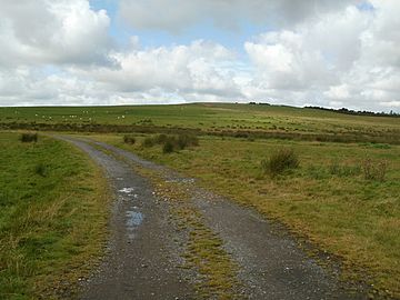
Mynydd y Drum, viewed from the east
|
|
| Highest point | |
| Elevation | 298 m (978 ft) |
| Geography | |
| Location | Neath Port Talbot, Wales |
| OS grid | SN807098 |
Mynydd y Drum is a hill located in south Wales. It sits right on the border between two areas: Powys and Neath Port Talbot. The very top of the hill, which is 298 meters (about 978 feet) high, is in Neath Port Talbot. This hill is part of a long, curving ridge. The larger part of this ridge is in Powys.
The eastern side of Mynydd y Drum is currently being used for opencast coal mining. This means coal is dug up from the surface. People sometimes call the hill simply The Drum. This comes from the Welsh word "Drum," which is pronounced "drim."
Contents
What is Mynydd y Drum?
Mynydd y Drum is a hill in Wales. It is located where the county of Powys meets the county borough of Neath Port Talbot. The highest point of the hill is 298 meters (978 feet) above sea level. This makes it a noticeable feature in the landscape.
The hill is part of a longer ridge. Most of this ridge is in Powys. The top part of Mynydd y Drum itself is in Neath Port Talbot. This area used to be part of a county called Glamorgan.
How the Hill Was Formed (Geology)
Mynydd y Drum is made up of different types of rock. These rocks are mostly sandstones and mudstones. They belong to a group of rocks called the Coal Measures Group. This group is found across South Wales.
Inside these rocks, there are many layers of coal. These coal layers are currently being dug up. This happens at a large mining site called the Nant Helen Opencast Coal Mine.
Old Stories and History (Archaeology)
Around the top of Mynydd y Drum, you can find several old stone piles. These are called cairns. We don't know exactly how old they are. One famous cairn, known as Garn Goch, was removed because of the opencast mining.
You can also find remains of old tramroads around the sides of the hill. These tramroads were like old railways. They were used in the 1800s to move coal and other materials. One important tramroad was Claypon's Tramroad extension. It was part of the Brecon Forest Tramroad. This tramroad connected places like Onllwyn with Ystalyfera in the Swansea Valley.
Exploring the Hill (Access)
Most of Mynydd y Drum is open for people to explore. This means walkers can go almost anywhere they like. However, the area where coal is being mined is not open to the public for safety reasons.
There are also many public footpaths and bridleways. These are special paths for walking or horse riding. They help people get onto the lower parts of the hill. You can reach these paths from nearby towns. These include Abercraf and Ystradgynlais in the upper Swansea Valley. You can also access the hill from Seven Sisters and Blaendulais. These places are at the top of the Dulais valley.
Legends of the Hill (Folklore)
Mynydd y Drum has a special legend. People say that three large pots of gold are buried on the hill's summit. These treasures are guarded by powerful demons. The legend also includes a prophecy. It says that one day, a young girl will be the one to find and claim this hidden treasure.
 | Bayard Rustin |
 | Jeannette Carter |
 | Jeremiah A. Brown |

