Myrtletown, Queensland facts for kids
Myrtletown used to be a small town, but now it's an industrial area. It's located within the suburb of Pinkenba, which is part of the City of Brisbane in Queensland, Australia.
Contents
Where is Myrtletown?
Myrtletown is in the northern part of Pinkenba. It sits close to the northern side of the Brisbane River, right where the river meets the sea. The very tip of Myrtletown, where the river opens up, is called Luggage Point. It's also known as Uniacke Point.
A waterway called Boggy Creek also flows into the Brisbane River in this area.
Myrtletown's Past
This area was first known as Boggy Creek, named after the creek. The name Myrtletown came from a group of myrtle trees that grew there. By 1928, these trees had disappeared.
Luggage Point's History
Luggage Point was first named Uniacke Point in 1823 by John Oxley. He was exploring the Brisbane River. The point was named after John Fitzgerald Uniacke, who was a scientist on Oxley's trip.
However, by 1839, people also called it Luggage Point. This name came from a special practice. Ships used to drop off their luggage here so they could cross a shallow part of the river more easily. The luggage would then be taken up the river separately.
Today, the main sewerage treatment plant for Brisbane is located at Luggage Point. It's now called the Luggage Point Resource Recovery Centre.
How Myrtletown Grew
At first, Myrtletown was mainly used for fishing and collecting oysters. Around 1881, a farmer named John Chapman started a farm there. By 1928, it had grown into a small town. It had about 250 people living there, surrounded by farms.
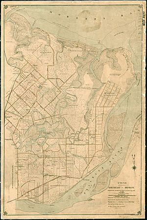
An old map from 1889 shows what the town looked like. Many families who lived there were descendants of early settlers. They grew fruits like bananas, grapes, and other vegetables like tomatoes and cabbages. They also caught prawns and fish from Boggy Creek.
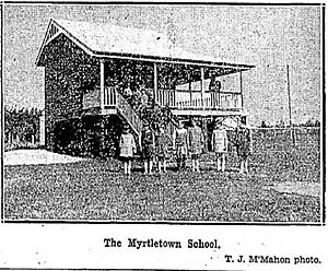
People living in Myrtletown asked for a local school in 1922. Myrtletown State School opened in 1924. It closed many years later, on February 19, 1971. The school was located where Lewandowski Drive and Sandmere Street meet today.
In 1928, the town had a Methodist church. There was no post office, but buses ran to Brisbane several times a day.
Brisbane's First Sewerage Plant
Brisbane's first large-scale sewerage treatment plant opened at Luggage Point on November 23, 1923. It was the first of its kind in Australia. This plant was a key part of Brisbane's sewerage system, which started in 1914. An electric tramway helped service the plant.
Changes Due to the Airport
Myrtletown used to be a quiet, semi-rural area. But when the Brisbane Airport was built nearby, most residents moved away. Since then, the area has become more and more industrial.
New Cruise Ship Terminal
A new cruise ship terminal opened in June 2022. It's called the Brisbane International Cruise Terminal. This new terminal is located on the northern bank of the Brisbane River, right next to the Luggage Point Resource Recovery Centre.
It can welcome the largest cruise ships in the world. This terminal is operated by the Port of Brisbane.
 | George Robert Carruthers |
 | Patricia Bath |
 | Jan Ernst Matzeliger |
 | Alexander Miles |


