Māhia Peninsula facts for kids
Quick facts for kids
Māhia Peninsula
|
|
|---|---|

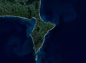
NASA satellite image of Māhia Peninsula
|
|
| Country | New Zealand |
| Region | Hawke's Bay |
| Territorial authority | Wairoa |
| Ward |
|
| Electorates |
|
| Area | |
| • Total | 157.25 km2 (60.71 sq mi) |
| Time zone | UTC+12 (NZST) |
| • Summer (DST) | UTC+13 (NZDT) |
| Postcode |
4198
|
The Māhia Peninsula (Maori: Māhia or Te Māhia) is a special place on the east coast of New Zealand's North Island. You can find it in the Hawke's Bay region, located between the towns of Wairoa and Gisborne.
This peninsula is famous for being home to Rocket Lab's Launch Complex 1. This is where they launch their Electron rockets into space! The launch site is near Ahuriri Point, right at the southern tip of the Māhia Peninsula.
Since 2018, Rocket Lab has used this site to send small satellites into orbit. These satellites can weigh between 135 and 235 kilograms. They also launch tiny satellites called CubeSats. New Zealand's very first rocket launch into orbit happened here on January 21, 2018.
Contents
Exploring the Geography of Māhia Peninsula
The Māhia Peninsula is about 21.7 kilometers (13.5 miles) long and 11.3 kilometers (7 miles) wide. Its tallest point is a hill called Rahuimokairoa, which stands 397 meters (1,302 feet) above sea level.
Long ago, the Māhia Peninsula was actually an island. But over time, a natural land bridge, called a tombolo, formed. This tombolo now connects the peninsula to the North Island.
Who Lives on the Māhia Peninsula?
Māhia Beach is a small rural community located on the northeast coast of the peninsula. In 2018, about 183 people lived there. The population can change a lot, especially during holidays.
The wider Māhia area, which includes nearby places like Nūhaka, had about 1,119 people living there in 2018. Many people in the Māhia area are of European or Māori background.
A Look at Māhia's History and Culture
Ancient Māori Stories and Meanings
According to Māori legends, a famous explorer named Whatonga came to New Zealand looking for his grandfather, Toi. Whatonga eventually settled in Māhia.
The peninsula is the traditional home of the Ngāti Rongomaiwahine iwi (tribe). The word māhia can mean "indistinct sound" or "scrofulous swelling." The full name "Te Māhia" comes from "Te Māhia-mai-tawhiti," which means "the sound heard from a distance."
Just off the southern tip of the peninsula is a small island called Portland Island, also known as Waikawa. The name Waikawa was given by Kahungunu. He visited the island hoping to find fresh water but only found salty water. Waikawa means "sour water." Portland Island has a lighthouse that operates automatically.
European Connections and Modern Times
In the past, shore whaling was important on the Māhia Peninsula for a short time. Early whalers had a station on a farm called "Kini Kini." Today, the community on the peninsula is still a mix of Māori and European people.
A fun fact: New Zealand's former Prime Minister, Jacinda Ardern, was proposed to by her partner, Clarke Gayford, on Mokotahi Hill, which is on the peninsula.
Marae: Important Meeting Places
There are five marae (traditional Māori meeting grounds) in the Māhia area. These marae are connected to the hapū (sub-tribes) of the Rongomaiwahine iwi:
- The Kaiuku or Oku-ra-renga Marae and its Kiwi meeting house are linked to the Ngāi Tama and Ngāi Tū hapū.
- Te Rākatō Marae is linked to the Ngāi Te Rākatō hapū.
- Tuahuru Marae and its Hine te Rongo meeting house are linked to the Ngai Tama and Ngāi Tū hapū.
- Ruawharo Marae is also linked to Ngai Tama.
- Mahanga Marae and its meeting house, Te Poho o Rongomaiwahine, are home to the Te Hokowhitu o Ngai Tu hapū.
In 2020, the New Zealand Government helped upgrade some of these marae. This created jobs and helped preserve these important cultural sites.
What is the Economy of Māhia Like?
Farms with sheep and cattle are important to the local community. However, tourism is now the main industry for the Māhia Peninsula. Many people visit during the warmer months and school holidays.
Māhia is well known for its great surfing spots, places for scuba diving, hiking trails, and fishing. The Morere Hot Springs are also nearby, about 15 minutes away towards Gisborne. The area is a popular holiday spot and has a holiday park that has been around since the 1960s. Many of the houses here are holiday homes or small beach houses called baches.
From 2007 to 2010, Māhia became famous for a friendly dolphin named Moko who lived in the waters nearby.
As mentioned, the peninsula is also the site of Rocket Lab Launch Complex 1. This facility has been used to launch satellites for different purposes, including spy satellites for the United States.
Learning in Māhia: Education
Te Mahia School is a primary school for students from Year 1 to Year 8. It is a co-educational state school, meaning both boys and girls attend. The school first opened in 1917.
What is the Climate Like in Māhia?
| Climate data for Mahia (1991–2020 normals, extremes 1990–present) | |||||||||||||
|---|---|---|---|---|---|---|---|---|---|---|---|---|---|
| Month | Jan | Feb | Mar | Apr | May | Jun | Jul | Aug | Sep | Oct | Nov | Dec | Year |
| Record high °C (°F) | 32.6 (90.7) |
34.9 (94.8) |
30.9 (87.6) |
26.5 (79.7) |
26.0 (78.8) |
21.0 (69.8) |
20.6 (69.1) |
21.5 (70.7) |
22.5 (72.5) |
26.4 (79.5) |
28.1 (82.6) |
30.0 (86.0) |
34.9 (94.8) |
| Mean daily maximum °C (°F) | 21.8 (71.2) |
21.7 (71.1) |
20.2 (68.4) |
17.9 (64.2) |
15.8 (60.4) |
13.5 (56.3) |
12.7 (54.9) |
13.2 (55.8) |
14.9 (58.8) |
16.7 (62.1) |
18.1 (64.6) |
20.1 (68.2) |
17.2 (63.0) |
| Daily mean °C (°F) | 18.4 (65.1) |
18.6 (65.5) |
17.1 (62.8) |
15.1 (59.2) |
13.2 (55.8) |
11.0 (51.8) |
10.3 (50.5) |
10.5 (50.9) |
11.9 (53.4) |
13.4 (56.1) |
14.8 (58.6) |
16.8 (62.2) |
14.3 (57.7) |
| Mean daily minimum °C (°F) | 14.9 (58.8) |
15.4 (59.7) |
14.1 (57.4) |
12.3 (54.1) |
10.5 (50.9) |
8.5 (47.3) |
7.8 (46.0) |
7.9 (46.2) |
8.9 (48.0) |
10.1 (50.2) |
11.4 (52.5) |
13.5 (56.3) |
11.3 (52.3) |
| Record low °C (°F) | 7.3 (45.1) |
6.0 (42.8) |
6.0 (42.8) |
4.6 (40.3) |
1.3 (34.3) |
2.5 (36.5) |
0.5 (32.9) |
0.6 (33.1) |
2.0 (35.6) |
3.0 (37.4) |
4.3 (39.7) |
5.9 (42.6) |
0.5 (32.9) |
| Average rainfall mm (inches) | 53.6 (2.11) |
67.3 (2.65) |
89.6 (3.53) |
97.4 (3.83) |
99.7 (3.93) |
123.6 (4.87) |
143.6 (5.65) |
101.1 (3.98) |
70.2 (2.76) |
69.6 (2.74) |
72.5 (2.85) |
68.3 (2.69) |
1,056.5 (41.59) |
| Source: NIWA | |||||||||||||
See also
 In Spanish: Península Mahia para niños
 | Georgia Louise Harris Brown |
 | Julian Abele |
 | Norma Merrick Sklarek |
 | William Sidney Pittman |


